File:2018-09-19 52 09 18 Map.jpg
From Geohashing
No higher resolution available.
2018-09-19_52_09_18_Map.jpg (268 × 491 pixels, file size: 159 KB, MIME type: image/jpeg)
See 2018-09-19 52 9 for more information.
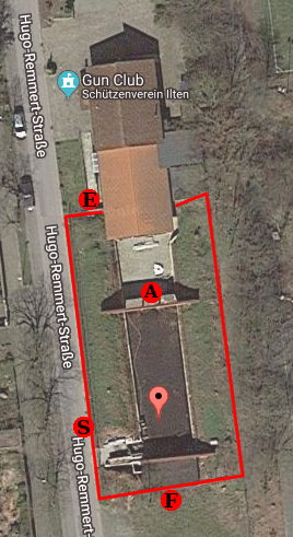
- A: The point my ambassadorship got me to
- E: The edge between the building and the fence
- F: The closest I got to the geohash from the fence at the parking lot
- S: The closest I got to the geohash from the fence at the street
Map data ©2018 GeoBasis-DE/BKG (©2009), Google Imagery ©2018, DigitalGlobe, GeoBasis-DE/BKG, GeoContent
File history
Click on a date/time to view the file as it appeared at that time.
| Date/Time | Thumbnail | Dimensions | User | Comment | |
|---|---|---|---|---|---|
| current | 15:22, 30 January 2020 | | 268 × 491 (159 KB) | Maintenance script (talk | contribs) |
- You cannot overwrite this file.
File usage
The following page links to this file: