Difference between revisions of "2024-05-19 37 -113"
(→Location) |
m (Location) |
||
| (4 intermediate revisions by 2 users not shown) | |||
| Line 1: | Line 1: | ||
| − | + | {{meetup graticule|date=2024-05-19|lat=37|lon=-113}} | |
| − | |||
| − | |||
| − | |||
| − | |||
| − | |||
| − | |||
| − | |||
| − | - | ||
| − | | lat= | ||
| − | | lon= | ||
| − | |||
| − | }} | ||
== Location == | == Location == | ||
Private Property just off a mountain road. Flat plains-like area with some trees. | Private Property just off a mountain road. Flat plains-like area with some trees. | ||
== Participants == | == Participants == | ||
| − | + | *[[User:Rheppy|Rheppy]] | |
| − | |||
| − | |||
| − | |||
| − | |||
== Expedition == | == Expedition == | ||
| − | + | A newfound fan of XKCD comics, I was reading Randall's About Me page and came across Geohashing. That led me to do my first one today with my family. On our drive to the Geohash, we almost hit a car, then drove up a narrow mountain road, driving past No Trespassing signs on a narrow road until we came within about 500 meters of the geohash. Someone in a side-by-side drove up, asked what we were doing, we explained, and he went to go talk to another person, who gave us permission to go on his land. I don't know if we got quite close enough to have technically reached the geohash since I was in a rush and they had a gun, but otherwise, it was an eventful hash. I think I'm the only person in Utah to do this right now so...yay! | |
| − | == | + | == Photos == |
| − | |||
| − | |||
| − | |||
| − | |||
| − | |||
<gallery perrow="5"> | <gallery perrow="5"> | ||
| + | 2024-05-19 37 -113Proof.jpg | Probably not good enough proof | ||
| + | 2024-05-19 37 -113Amountain.jpg | It's a mountain | ||
| + | 2024-05-19 37 -113Afence.jpg | The second fence of no passage (Another Property) | ||
| + | 2024-05-19 37 -113moremountain.jpg | Wow. More mountain. | ||
| + | 2024-05-19 37 -113Treeandmountain.jpg | MOUNTAIN (and trees) | ||
</gallery> | </gallery> | ||
| Line 40: | Line 24: | ||
__NOTOC__ | __NOTOC__ | ||
| − | |||
| − | |||
| − | |||
| − | |||
| − | |||
| − | |||
| − | |||
| − | |||
| − | |||
| − | |||
[[Category:Expeditions]] | [[Category:Expeditions]] | ||
| − | |||
[[Category:Expeditions with photos]] | [[Category:Expeditions with photos]] | ||
| − | + | [[Category:Coordinates not reached]] <!-- about 55 meters off accourding to the proof photo --> | |
| − | |||
| − | |||
| − | |||
| − | [[Category:Coordinates reached]] | ||
| − | |||
| − | |||
| − | |||
| − | |||
| − | |||
| − | |||
| − | |||
| − | |||
[[Category:Not reached - No public access]] | [[Category:Not reached - No public access]] | ||
| − | + | {{location|US|UT|RN}} | |
| − | |||
| − | |||
| − | |||
| − | |||
| − | |||
| − | {{ | ||
| − | | | ||
| − | | | ||
| − | | | ||
Latest revision as of 19:42, 20 May 2024
| Sun 19 May 2024 in 37,-113: 37.5388936, -113.0974074 geohashing.info google osm bing/os kml crox |
Location
Private Property just off a mountain road. Flat plains-like area with some trees.
Participants
Expedition
A newfound fan of XKCD comics, I was reading Randall's About Me page and came across Geohashing. That led me to do my first one today with my family. On our drive to the Geohash, we almost hit a car, then drove up a narrow mountain road, driving past No Trespassing signs on a narrow road until we came within about 500 meters of the geohash. Someone in a side-by-side drove up, asked what we were doing, we explained, and he went to go talk to another person, who gave us permission to go on his land. I don't know if we got quite close enough to have technically reached the geohash since I was in a rush and they had a gun, but otherwise, it was an eventful hash. I think I'm the only person in Utah to do this right now so...yay!
Photos
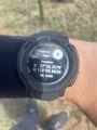
Probably not good enough proof
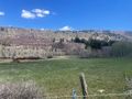
It's a mountain
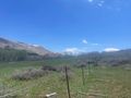
The second fence of no passage (Another Property)
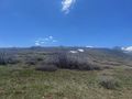
Wow. More mountain.
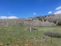
MOUNTAIN (and trees)


