Difference between revisions of "2024-05-23 43 -79"
From Geohashing
([live picture]The view north) |
|||
| Line 13: | Line 13: | ||
}}<!-- edit as necessary --> | }}<!-- edit as necessary --> | ||
== Location == | == Location == | ||
| − | + | At the intersection of Greenlaw and MacKay, near St. Clair West and Earlscourt. | |
== Participants == | == Participants == | ||
| − | + | *[[User:Frogman|Frogman]] | |
| − | + | *[[User:Benture|Benture]] | |
| − | + | *Kate | |
| − | |||
| − | |||
== Expedition == | == Expedition == | ||
| − | + | This hashpoint was a very convenient fifteen minute walk from my (Frogman) apartment. We met up for brunch at Boom Breakfast, a diner that I had never been to before. It was good! Afterwards we walked over to the hashpoint and snapped a couple of photos. | |
| − | |||
| − | |||
| − | |||
== Photos == | == Photos == | ||
| Line 45: | Line 40: | ||
== Achievements == | == Achievements == | ||
{{#vardefine:ribbonwidth|100%}} | {{#vardefine:ribbonwidth|100%}} | ||
| − | + | {{Walk geohash | |
| − | + | | latitude = 43 | |
| − | + | | longitude = -79 | |
| − | + | | date = 2024-05-23 | |
| − | [[ | + | | name = [[User:Frogman|Frogman]] |
| + | | distance = 1.3 km | ||
| − | + | }} | |
| − | |||
| − | |||
| − | |||
| − | + | __NOTOC__ | |
[[Category:Expeditions]] | [[Category:Expeditions]] | ||
| − | |||
[[Category:Expeditions with photos]] | [[Category:Expeditions with photos]] | ||
| − | |||
| − | |||
| − | |||
| − | |||
[[Category:Coordinates reached]] | [[Category:Coordinates reached]] | ||
| − | |||
| − | |||
| − | |||
| − | |||
| − | |||
| − | |||
| − | |||
| − | |||
| − | |||
| − | |||
| − | |||
| − | |||
| − | |||
| − | |||
Revision as of 14:25, 24 May 2024
| Thu 23 May 2024 in 43,-79: 43.6760320, -79.4477763 geohashing.info google osm bing/os kml crox |
Location
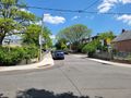
At the intersection of Greenlaw and MacKay, near St. Clair West and Earlscourt.
Participants
Expedition
This hashpoint was a very convenient fifteen minute walk from my (Frogman) apartment. We met up for brunch at Boom Breakfast, a diner that I had never been to before. It was good! Afterwards we walked over to the hashpoint and snapped a couple of photos.
Photos

Proof that we arrived
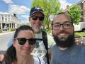
Us
The view east

The view north


Achievements
Frogman earned the Walk geohash Achievement
|