|
|
| Line 1: |
Line 1: |
| − | <!-- If you did not specify these parameters in the template, please substitute appropriate values for IMAGE, LAT, LON, and DATE (YYYY-MM-DD format)
| + | {{meetup graticule|date=2024-05-27|lat=49|lon=10}} |
| − | | |
| − | [[Image:{{{image|IMAGE}}}|thumb|left]]
| |
| − | | |
| − | Remove this section if you don't want an image at the top (left) of your report. You should remove the "Image:" or "File:"
| |
| − | tag from your image file name, and replace the all upper-case word IMAGE in the above line.
| |
| − | | |
| − | And DON'T FORGET to add your expedition and the best photo you took to the gallery on the Main Page! We'd love to read your report, but that means we first have to discover it! :)
| |
| − | -->{{meetup graticule|date=2024-05-27|lat=49|lon=10}}
| |
| | == Location == | | == Location == |
| − | <!-- where you've surveyed the hash to be -->
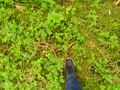
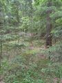
| + | This Geohash is located in a forest in Langenzenn. |
| | | | |
| | == Participants == | | == Participants == |
| − | <!-- who attended: If you link to your wiki user name in this section, your expedition will be picked up by the various statistics generated for geohashing. You may use three tildes ~ as a shortcut to automatically insert the user signature of the account you are editing with.
| + | *[[User:Torodeas|Torodeas]] |
| − | -->
| |
| | | | |
| | == Plans == | | == Plans == |
| Line 25: |
Line 16: |
| | | | |
| | == Photos == | | == Photos == |
| − | <!-- Insert pictures between the gallery tags using the following format:
| |
| − | Image:2024-##-## ## ## Alpha.jpg | Witty Comment
| |
| − | -->
| |
| | <gallery perrow="5"> | | <gallery perrow="5"> |
| − |
| |
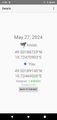
| | Image:2024-05-27_49_10_Torodeas_1716833847276.jpg|Laubendorf train station | | Image:2024-05-27_49_10_Torodeas_1716833847276.jpg|Laubendorf train station |
| − |
| |
| | Image:2024-05-27_49_10_Torodeas_1716833847286.jpg|Proof | | Image:2024-05-27_49_10_Torodeas_1716833847286.jpg|Proof |
| − |
| |
| | Image:2024-05-27_49_10_Torodeas_1716833847320.jpg|At the hash | | Image:2024-05-27_49_10_Torodeas_1716833847320.jpg|At the hash |
| − |
| |
| | Image:2024-05-27_49_10_Torodeas_1716833847349.jpg|View from hash | | Image:2024-05-27_49_10_Torodeas_1716833847349.jpg|View from hash |
| | </gallery> | | </gallery> |
| Line 44: |
Line 28: |
| | | | |
| | __NOTOC__ | | __NOTOC__ |
| − | <!-- =============== USEFUL CATEGORIES FOLLOW ================
| |
| − | Delete the next line ONLY if you have chosen the appropriate categories below. If you are unsure, don't worry. People will read your report and help you with the classification. -->
| |
| − | [[Category:New report]]
| |
| − |
| |
| − | <!-- Potential categories. Please include all the ones appropriate to your expedition -->
| |
| − | <!-- If this is a planning page:
| |
| − | [[Category:Expedition planning]]
| |
| − | -->
| |
| − |
| |
| − | <!-- An actual expedition:
| |
| | [[Category:Expeditions]] | | [[Category:Expeditions]] |
| − | -- and one or more of --
| |
| | [[Category:Expeditions with photos]] | | [[Category:Expeditions with photos]] |
| − | [[Category:Expeditions with videos]]
| |
| − | -->
| |
| − |
| |
| − | <!-- if you reached your coordinates:
| |
| | [[Category:Coordinates reached]] | | [[Category:Coordinates reached]] |
| − |
| |
| − | --><!-- or if you did not reach the coordinates:
| |
| − | [[Category:Coordinates not reached]]
| |
| − | -- and a reason --
| |
| − | When there is a natural obstacle between you and the target:
| |
| − | [[Category:Not reached - Mother Nature]]
| |
| − |
| |
| − | When there is a man-made obstacle between you and the target:
| |
| − | [[Category:Not reached - No public access]]
| |
| − |
| |
| − | When you failed get your GPS, car, bike or such to work:
| |
| − | [[Category:Not reached - Technology]]
| |
| − |
| |
| − | (Don't forget to delete this final close comment marker) -->
| |