Difference between revisions of "2024-05-23 39 8"
Green guy! (talk | contribs) (Create expedition page) |
Green guy! (talk | contribs) (Add witty captions to gallery) |
||
| (One intermediate revision by the same user not shown) | |||
| Line 1: | Line 1: | ||
<!-- Title image (optional) --> | <!-- Title image (optional) --> | ||
| − | + | [[File:OMIMG_20240523_201503.jpg|thumb|right]] | |
| − | |||
| − | |||
{{meetup graticule | {{meetup graticule | ||
| lat={{#explode:{{SUBPAGENAME}}| |1}} | | lat={{#explode:{{SUBPAGENAME}}| |1}} | ||
| Line 9: | Line 7: | ||
}} | }} | ||
== Location == | == Location == | ||
| − | |||
On a private allotment or orchard, about 70 meters away from the closest road, in Santa Barbara, Province of Cagliari, Sardinia, Italy. The closest settlements are Sarroch in northeast direction and Villa San Pietro in south direction. | On a private allotment or orchard, about 70 meters away from the closest road, in Santa Barbara, Province of Cagliari, Sardinia, Italy. The closest settlements are Sarroch in northeast direction and Villa San Pietro in south direction. | ||
| Line 38: | Line 35: | ||
== Tracklog: Taxi ride from airport to hotel == | == Tracklog: Taxi ride from airport to hotel == | ||
| − | + | * I forgot to immediately start the tracklog. | |
| − | |||
| − | * I forgot to immediately start the tracklog | ||
* Direction: south | * Direction: south | ||
| − | * GPS accuracy: | + | * GPS accuracy: good |
| − | * Markers show all locations where I took photos | + | * Markers show all locations where I took photos. |
| − | + | {{Tracklog|GH 2024-05-23 19 46.gpx}} | |
| − | |||
== Pictures == | == Pictures == | ||
| − | |||
| − | |||
<gallery> | <gallery> | ||
| + | File:OMIMG_20240523_194808.jpg | Beautiful seaside sunset | ||
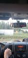
| + | File:OMIMG_20240523_194849.jpg | Taxi front-seat perspective | ||
| + | File:OMIMG_20240523_195128.jpg | Did I capture a flamingo on camera? | ||
| + | File:OMIMG_20240523_195514.jpg | More solar beauty | ||
| + | File:OMIMG_20240523_200706.jpg | Approaching a short tunnel | ||
| + | File:OMIMG_20240523_201503.jpg | Respecting private property even though the gate is open <small>(ignore the phone case’s flap on the top right)</small> | ||
| + | File:OMIMG_20240523_201729.jpg | One final view at the hashsite from our taxi while doing a u-turn | ||
| + | File:OMIMG_20240523_203230.jpg | Hotel reached | ||
</gallery> | </gallery> | ||
| − | |||
== Achievements == | == Achievements == | ||
| Line 87: | Line 86: | ||
__NOTOC__ | __NOTOC__ | ||
| − | |||
| − | |||
| − | |||
| − | |||
| − | |||
| − | |||
[[Category:Expeditions]] | [[Category:Expeditions]] | ||
| − | + | [[Category:Expeditions with photos]] | |
| − | |||
[[Category:Coordinates not reached]] | [[Category:Coordinates not reached]] | ||
[[Category:Not reached - No public access]] | [[Category:Not reached - No public access]] | ||
Revision as of 10:36, 10 June 2024

| Thu 23 May 2024 in 39,8: 39.0493427, 8.9907290 geohashing.info google osm bing/os kml crox |
Location
On a private allotment or orchard, about 70 meters away from the closest road, in Santa Barbara, Province of Cagliari, Sardinia, Italy. The closest settlements are Sarroch in northeast direction and Villa San Pietro in south direction.
This day’s weather: sunny / mild-warm
Participants
- Green guy! (talk)
- Green guy!’s mother (no consent to publish photos of her)
- Green guy!’s father (no consent to publish photos of him)
- Italian taxi driver (no consent to publish photos of him)
Plans
- After landing in Cagliari Airport, take the car rented beforehand (around 7:00–7:30 pm)
- On the way towards the hotel Flamingo Resort & Spa, take a quick detour to visit the hashpoint
- After that, continue towards the hotel with the rental car
Expedition
Shockingly for us, there was a problem with the car rental at Cagliari Airport: We rented the car for exactly 10:30 am even though we knew we’d arrive later – because my parents thought “10:30 am” meant “from 10:30 am to any later time”. The result: Someone else received the rental car meant for us. We could barely convince the desk person to refund the rental fee (as we had paid in advance).
With no rental car being available for us, reaching the coordinates seemed to be almost impossible both in the technological and time constraint kind (as it was 7:30 pm at the time and we wanted to have dinner at the hotel).
We settled on the alternative to get driven to the hotel by taxi. After approaching one, we immediately asked the driver whether he would be willing to take a detour from the regular route. Communication was somewhat difficult, as the Italian driver only understands a few bits of English (and no German).
The taxi driver agreed and even had quite some fun taking the detour. We drove as close as possible to the hashpoint, but it turned out that the coordinates lie on private property (allotments or orchards). At that moment, the entrance gate was open, but we asked the owner and he (obviously) said “no”, earning me the No Trespassing achievement. Anyway, we saw a family with children on the property and the taxi driver had a short chat with the owner. It was a beautiful sight and, overall, a joyful experience for all of us, including the taxi driver.
Finally, we continued to our hotel, Flamingo Resort & Spa, to start our actual vacation. Upon arriving, we gave the taxi driver a big tip for the detour.
Tracklog: Taxi ride from airport to hotel
- I forgot to immediately start the tracklog.
- Direction: south
- GPS accuracy: good
- Markers show all locations where I took photos.
Pictures
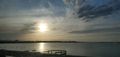
Beautiful seaside sunset
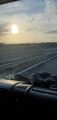
Taxi front-seat perspective
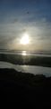
Did I capture a flamingo on camera?
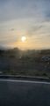
More solar beauty
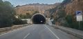
Approaching a short tunnel
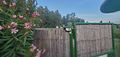
Respecting private property even though the gate is open (ignore the phone case’s flap on the top right)
One final view at the hashsite from our taxi while doing a u-turn

Hotel reached


Achievements
First-time
I earned these for the first time from this geohash.
Green guy! (talk) earned the No trespassing consolation prize
|
