Difference between revisions of "2024-06-08 51 5"
FelixTheCat (talk | contribs) (Created page with "{{subst:Expedition}}") |
FelixTheCat (talk | contribs) |
||
| Line 1: | Line 1: | ||
| − | + | {{meetup graticule|date=2024-06-08|lat=51|lon=5}} | |
| − | |||
| − | |||
| − | |||
| − | |||
| − | |||
| − | |||
| − | |||
| − | |||
== Location == | == Location == | ||
| − | + | On the edge of a field near Culemborg, Gelderland province. | |
== Participants == | == Participants == | ||
| − | + | [[User:FelixTheCat|FelixTheCat]] ([[User talk:FelixTheCat|talk]]) | |
| − | |||
| − | |||
| − | |||
| − | |||
== Expedition == | == Expedition == | ||
| − | + | Today there was finally a hash again in a reasonable location. It was right on the edge of a farmer's field, but also on a public path known as a ''klompenpad'' (literally "clog path"), which is an unpaved path through a rural landscape. I had to go to an appointment in the afternoon and needed only a reasonable detour from that trip to reach the hash. I parked the hashmobile at a small car park nearby and walked the remaining bit. Clog paths are so named because they can be pretty muddy, and are therefore best traversed in traditional wooden shoes, but today's path was pretty solid and accessible with regular footwear. I found the point, took some pictures and then went back on the road. | |
| − | |||
| − | |||
| − | |||
== Photos == | == Photos == | ||
| − | |||
| − | |||
| − | |||
<gallery perrow="5"> | <gallery perrow="5"> | ||
| + | Image:2024-06-08 51 5 FelixTheCat 1.JPG | The closest car park was next to this bisected bunker. | ||
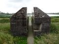
| + | Image:2024-06-08 51 5 FelixTheCat 2.JPG | There's another, overgrown, bunker nearby. All of this stuff was part of the [https://en.wikipedia.org/wiki/Dutch_Waterline#New_Dutch_Waterline New Dutch Waterline], a UNESCO World Heritage Site. | ||
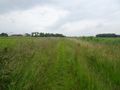
| + | Image:2024-06-08 51 5 FelixTheCat 3.JPG | The clog path starts here. | ||
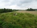
| + | Image:2024-06-08 51 5 FelixTheCat 4.JPG | Luckily, it isn't too cloggy today. The point is right ahead. | ||
| + | Image:2024-06-08 51 5 FelixTheCat 5.png | Made it! | ||
| + | Image:2024-06-08 51 5 FelixTheCat 10.JPG | Lloyd, Harriet and Hermelien celebrating at the spot. | ||
| + | Image:2024-06-08 51 5 FelixTheCat 6.JPG | Looking to the west. | ||
| + | Image:2024-06-08 51 5 FelixTheCat 7.JPG | To the north. | ||
| + | Image:2024-06-08 51 5 FelixTheCat 8.JPG | To the east. | ||
| + | Image:2024-06-08 51 5 FelixTheCat 9.JPG | And to the south. | ||
</gallery> | </gallery> | ||
== Achievements == | == Achievements == | ||
{{#vardefine:ribbonwidth|100%}} | {{#vardefine:ribbonwidth|100%}} | ||
| − | + | {{land geohash | |
| − | + | | latitude = 51 | |
| + | | longitude = 5 | ||
| + | | date = 2024-06-08 | ||
| + | | name = [[User:FelixTheCat|FelixTheCat]] ([[User talk:FelixTheCat|talk]]) | ||
| + | }} | ||
__NOTOC__ | __NOTOC__ | ||
| − | |||
| − | |||
| − | |||
| − | |||
| − | |||
| − | |||
| − | |||
| − | |||
| − | |||
| − | |||
[[Category:Expeditions]] | [[Category:Expeditions]] | ||
| − | |||
[[Category:Expeditions with photos]] | [[Category:Expeditions with photos]] | ||
| − | |||
| − | |||
| − | |||
| − | |||
[[Category:Coordinates reached]] | [[Category:Coordinates reached]] | ||
| − | |||
| − | |||
| − | |||
| − | |||
| − | |||
| − | |||
| − | |||
| − | |||
| − | |||
| − | |||
| − | |||
| − | |||
| − | |||
| − | |||
Revision as of 21:06, 8 June 2024
| Sat 8 Jun 2024 in 51,5: 51.9411166, 5.1630293 geohashing.info google osm bing/os kml crox |
Location
On the edge of a field near Culemborg, Gelderland province.
Participants
Expedition
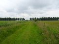
Today there was finally a hash again in a reasonable location. It was right on the edge of a farmer's field, but also on a public path known as a klompenpad (literally "clog path"), which is an unpaved path through a rural landscape. I had to go to an appointment in the afternoon and needed only a reasonable detour from that trip to reach the hash. I parked the hashmobile at a small car park nearby and walked the remaining bit. Clog paths are so named because they can be pretty muddy, and are therefore best traversed in traditional wooden shoes, but today's path was pretty solid and accessible with regular footwear. I found the point, took some pictures and then went back on the road.
Photos
The closest car park was next to this bisected bunker.
There's another, overgrown, bunker nearby. All of this stuff was part of the New Dutch Waterline, a UNESCO World Heritage Site.

The clog path starts here.
Luckily, it isn't too cloggy today. The point is right ahead.
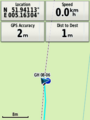
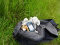
Made it!
Lloyd, Harriet and Hermelien celebrating at the spot.
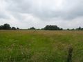
Looking to the west.
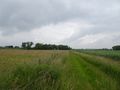
To the north.
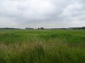
To the east.
And to the south.


Achievements
FelixTheCat (talk) earned the Land geohash achievement
|