Difference between revisions of "2024-06-09 51 7"
From Geohashing
Lam 'al Adie (talk | contribs) ([live picture]Local Playground [https://openstreetmap.org/?mlat=51.44536380&mlon=7.20074260&zoom=16 @51.4454,7.2007]) |
m (→Achievements) |
||
| (3 intermediate revisions by 3 users not shown) | |||
| Line 1: | Line 1: | ||
| − | + | {{meetup graticule|date=2024-06-09|lat=51|lon=7}} | |
| − | |||
| − | |||
| − | |||
| − | |||
| − | |||
| − | |||
| − | |||
| − | |||
== Location == | == Location == | ||
| − | + | This Geohash is located on a playground in Bochum-Weitmar. | |
== Participants == | == Participants == | ||
| − | + | *[[User:Lam 'al Adie|Lam 'al Adie]] | |
| − | + | *[[User:GeorgDerReisende|GeorgDerReisende]] | |
| − | |||
| − | |||
| − | |||
== Expedition == | == Expedition == | ||
| − | + | === GeorgDerReisende === | |
| − | + | This day was election day for the European Parliament. I went voting in the morning and then I traveled to Bochum to make this geohash. Before and after the geohashing I walked around the city. | |
| − | == | ||
| − | |||
== Photos == | == Photos == | ||
| − | + | === Lam 'al Adie === | |
| − | |||
| − | |||
<gallery perrow="5"> | <gallery perrow="5"> | ||
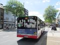
| + | Image:2024-06-09_51_7_Lam 'al Adie_1717942143524.jpg|Local Playground [https://openstreetmap.org/?mlat=51.44536380&mlon=7.20074260&zoom=16 @51.4454,7.2007] | ||
| + | </gallery> | ||
| + | === GeorgDerReisende === | ||
| − | + | <gallery> | |
| + | File:2024-06-09 51 7 GeorgDerReisende 3859.jpg | arrived | ||
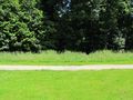
| + | File:2024-06-09 51 7 GeorgDerReisende 3885.jpg | the hash lay at the trees on the left side | ||
| + | File:2024-06-09 51 7 GeorgDerReisende 3887.jpg | proof | ||
| + | File:2024-06-09 51 7 GeorgDerReisende 3888.jpg | proof | ||
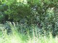
| + | File:2024-06-09 51 7 GeorgDerReisende 3889.jpg | looking north | ||
| + | File:2024-06-09 51 7 GeorgDerReisende 3890.jpg | east | ||
| + | File:2024-06-09 51 7 GeorgDerReisende 3891.jpg | south | ||
| + | File:2024-06-09 51 7 GeorgDerReisende 3892.jpg | west | ||
| + | File:2024-06-09 51 7 GeorgDerReisende 3893.jpg | GeorgDerReisende | ||
</gallery> | </gallery> | ||
| Line 36: | Line 33: | ||
{{#vardefine:ribbonwidth|100%}} | {{#vardefine:ribbonwidth|100%}} | ||
<!-- Add any achievement ribbons you earned below, or remove this section --> | <!-- Add any achievement ribbons you earned below, or remove this section --> | ||
| + | |||
| + | {{gratuitous ribbon | color = white | icon = Voting.png | latitude = 51 | longitude = 7 | date = 2024-06-09 | achievement = Democracy Geohash Achievement | description = going voting on the way to the | name = GeorgDerReisende }} | ||
| + | {{OSM|date=2024-06-09|latitude=51|longitude=7|name=[[User:GeorgDerReisende|GeorgDerReisende]]|OSMlink=152982309}} | ||
__NOTOC__ | __NOTOC__ | ||
| − | |||
| − | |||
| − | |||
| − | |||
| − | |||
| − | |||
| − | |||
| − | |||
| − | |||
| − | |||
[[Category:Expeditions]] | [[Category:Expeditions]] | ||
| − | |||
[[Category:Expeditions with photos]] | [[Category:Expeditions with photos]] | ||
| − | |||
| − | |||
| − | |||
| − | |||
[[Category:Coordinates reached]] | [[Category:Coordinates reached]] | ||
| − | + | {{location|DE|NW|BO}} | |
| − | |||
| − | |||
| − | |||
| − | |||
| − | |||
| − | |||
| − | |||
| − | |||
| − | |||
| − | |||
| − | |||
| − | |||
| − | |||
Latest revision as of 21:55, 4 July 2024
| Sun 9 Jun 2024 in 51,7: 51.4453591, 7.2005375 geohashing.info google osm bing/os kml crox |
Location
This Geohash is located on a playground in Bochum-Weitmar.
Participants
Expedition
GeorgDerReisende
This day was election day for the European Parliament. I went voting in the morning and then I traveled to Bochum to make this geohash. Before and after the geohashing I walked around the city.
Photos
Lam 'al Adie

Local Playground @51.4454,7.2007

GeorgDerReisende
arrived

the hash lay at the trees on the left side
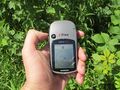
proof

proof

looking north
east

south
west

GeorgDerReisende


Achievements
GeorgDerReisende earned the Democracy Geohash Achievement
|
GeorgDerReisende earned the OpenStreetMap achievement
|