Difference between revisions of "2024-06-21 42 -85"
From Geohashing
(→Tracklog) |
(→Achievements) |
||
| (8 intermediate revisions by 2 users not shown) | |||
| Line 10: | Line 10: | ||
== Location == | == Location == | ||
<!-- where you've surveyed the hash to be --> | <!-- where you've surveyed the hash to be --> | ||
| + | This geohash is located near the intersection of 46th Street and 40th Avenue in Van Buren, Michigan. | ||
== Participants == | == Participants == | ||
<!-- who attended: If you link to your wiki user name in this section, your expedition will be picked up by the various statistics generated for geohashing. You may use three tildes ~ as a shortcut to automatically insert the user signature of the account you are editing with. | <!-- who attended: If you link to your wiki user name in this section, your expedition will be picked up by the various statistics generated for geohashing. You may use three tildes ~ as a shortcut to automatically insert the user signature of the account you are editing with. | ||
--> | --> | ||
| + | [[User:Ironeagl|Ironeagl]] ([[User talk:Ironeagl|talk]]) | ||
== Plans == | == Plans == | ||
| Line 20: | Line 22: | ||
== Expedition == | == Expedition == | ||
<!-- how it all turned out. your narrative goes here. --> | <!-- how it all turned out. your narrative goes here. --> | ||
| + | [[User:Ironeagl|Ironeagl]] ([[User talk:Ironeagl|talk]]) | ||
| + | After seeing that this hashpoint was accessible I decided to make the drive a bit more interesting and attempt the Tron achievement. I set up a route in my GPS and set out Friday evening. On the way to and from the hashpoint, I: | ||
| + | * Saw a lot of trees and farmland | ||
| + | * Passed by an active railroad-attached granary | ||
| + | * Crossed paths with several police vehicles, although they did not prevent me from reaching the hashpoint | ||
| + | * Nearly died because I mistook a one-way stop for an all-way stop | ||
| + | * Slowed down for about 10 deer in 5 separate groups | ||
| + | * Puzzled over a "YIELD except right turn" sign (turning right, I chose to stop) | ||
| + | * Found a "Speed limit 25 when flashing" sign without a light to flash | ||
| + | * Visited the [[2022-09-17 42 -86]] geohash for the second time | ||
| + | All in all, an adventurous expedition! | ||
| − | |||
| − | |||
| − | |||
== Tracklog == | == Tracklog == | ||
{{tracklog | 20240621-184307-Tron_sanitized_waypoints.gpx}} | {{tracklog | 20240621-184307-Tron_sanitized_waypoints.gpx}} | ||
| Line 32: | Line 42: | ||
--> | --> | ||
<gallery perrow="5"> | <gallery perrow="5"> | ||
| + | Image:Near the 2024-06-21 42 -85 hashpoint.jpg | Near the hashpoint | ||
| + | Image:Screenshot for Tron.png | Screenshot for Tron | ||
</gallery> | </gallery> | ||
== Achievements == | == Achievements == | ||
{{#vardefine:ribbonwidth|100%}} | {{#vardefine:ribbonwidth|100%}} | ||
| − | |||
| − | |||
| − | |||
| − | |||
| − | |||
| − | |||
| − | |||
| − | |||
| − | |||
| − | |||
| − | |||
| − | |||
| − | |||
[[Category:Expeditions]] | [[Category:Expeditions]] | ||
| − | + | [[Category:Coordinates reached]] | |
[[Category:Expeditions with photos]] | [[Category:Expeditions with photos]] | ||
| − | |||
| − | |||
| − | |||
| − | |||
| − | |||
| − | |||
| − | |||
| − | |||
| − | |||
| − | |||
| − | |||
| − | |||
| − | |||
| − | |||
| − | |||
| − | |||
| − | |||
| − | + | {{Tron | date = 2024-06-21 | latitude = 42 | longitude = -85 | name = Ironeagl | possessive = his | tracklog = https://geohashing.site/geohashing/File:Screenshot_for_Tron.png }} | |
| + | {{location|US|MI|VA}} | ||
Latest revision as of 02:12, 22 June 2024
| Fri 21 Jun 2024 in 42,-85: 42.2727127, -85.9938470 geohashing.info google osm bing/os kml crox |
Location
This geohash is located near the intersection of 46th Street and 40th Avenue in Van Buren, Michigan.
Participants
Plans
Expedition
Ironeagl (talk) After seeing that this hashpoint was accessible I decided to make the drive a bit more interesting and attempt the Tron achievement. I set up a route in my GPS and set out Friday evening. On the way to and from the hashpoint, I:
- Saw a lot of trees and farmland
- Passed by an active railroad-attached granary
- Crossed paths with several police vehicles, although they did not prevent me from reaching the hashpoint
- Nearly died because I mistook a one-way stop for an all-way stop
- Slowed down for about 10 deer in 5 separate groups
- Puzzled over a "YIELD except right turn" sign (turning right, I chose to stop)
- Found a "Speed limit 25 when flashing" sign without a light to flash
- Visited the 2022-09-17 42 -86 geohash for the second time
All in all, an adventurous expedition!
Tracklog
Photos
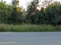
Near the hashpoint
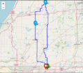
Screenshot for Tron


Achievements
Ironeagl earned the Tron achievement
|