Difference between revisions of "2024-06-27 -38 145"
(Created page with "{{subst:Expedition}}") |
|||
| (11 intermediate revisions by 2 users not shown) | |||
| Line 1: | Line 1: | ||
| − | + | {{meetup graticule|date=2024-06-27|lat=-38|lon=145}} | |
| + | == Location == | ||
| + | On a vacant plot in Pakenham | ||
| − | [[ | + | == Participants == |
| + | *[[User:BarbaraTables|BarbaraTables]] | ||
| − | + | == Expedition == | |
| − | + | === The Research === | |
| + | Finally, I've achieved a Geohash in the [[Pakenham,_Australia|Pakenham Graticule]]! As someone who lives closer than other Geohashers in Melbourne to this Graticule, I've had to wait a surprisingly long time to get one here. | ||
| − | + | The most notable part of this expedition was the research performed beforehand to ensure that this plot was still empty. The maps at [https://www.google.com/maps/@-38.058408,145.4618149,3a,75y,9.02h,86t/data=!3m6!1e1!3m4!1sAgPLd3d72Sguo6UIE-bH_A!2e0!7i16384!8i8192?coh=205409&entry=ttu the present] didn't indicate anything here, but the presence of a real estate office just on the corner seemed to indicate possible ongoing construction in this area. And lo and behold, winding back the Street View photographs a few years to [https://www.google.com/maps/@-38.0584249,145.4617663,3a,75y,14.46h,89.16t/data=!3m7!1e1!3m5!1sEJYdAPeJJZrB-lJDYs04rQ!2e0!5s20190701T000000!7i16384!8i8192?coh=205409&entry=ttu 2019] showed that the plot containing the Geohash was being worked on, possibly in preparation for a building. They added a building on part of this worked site - could they have added a building at the crucial location as well? | |
| − | |||
| − | == | ||
| − | |||
| − | + | I looked up this real estate company online, but the [https://www.openlot.com.au/mt-pleasant-estate-pakenham results] weren't clear. Were [https://www.openlot.com.au/mt-pleasant-estate-pakenham#communityGallery-1 these] [https://www.openlot.com.au/mt-pleasant-estate-pakenham#communityGallery-3 charts] indicating that they are currently using the entire plot for a small, temporary office? If those boxes are to scale, then there cannot be a new property where the Geohash is. It suggested to me that their plan was to keep the office until it has served its purpose, knock it down, then repurpose it, in order to retain the possibility of constructing a building taking up the entire plot. This area has a lot of large, industrial buildings. | |
| − | |||
| − | |||
| − | + | At the end of the day, there was only a span of maybe six months in which anything could have changed. But all it takes is construction to start, and then it's inaccessible. | |
| − | |||
| − | == | + | === The expedition === |
| − | + | I took a number of buses and trains to get there, and it was indeed accessible. Some of the ground was a bit yielding, so I walked against the back of those fences to keep on solid ground. It was in view of a couple passers-by and I'm sure it looked a bit suspicious and weird, but I definitely wasn't doing anything wrong. I didn't want to push it by taking a selfie on the spot - ''that'' definitely takes it from "I'm sure they know what they're doing" to "okay, wat". | |
| − | |||
| − | |||
| − | |||
| − | == | + | <gallery mode="packed" heights="300px"> |
| − | + | File:2024-06-27_-38_145_view_of_hash.JPEG|It's in the corner! | |
| − | + | File:2024-06-27_-38_145_view_at_hash.JPEG|Now I'm in the corner! | |
| − | -- | + | File:2024-06-27_-38_145_proof.PNG|Proof |
| − | |||
</gallery> | </gallery> | ||
| − | |||
{{#vardefine:ribbonwidth|100%}} | {{#vardefine:ribbonwidth|100%}} | ||
| − | + | {{land geohash | |
| + | |||
| + | | latitude = -38 | ||
| + | | longitude = 145 | ||
| + | | date = 2024-06-27 | ||
| + | | name = [[User:BarbaraTables|BarbaraTables]] | ||
| − | + | }} | |
| − | + | {{Minesweeper geohash | |
| − | |||
| − | |||
| − | + | | graticule = Melbourne West, Australia | |
| − | + | | ranknumber = 3 | |
| − | [[ | + | | n = true |
| − | + | | e = true | |
| + | | se = true | ||
| + | | name = [[User:BarbaraTables|BarbaraTables]] | ||
| − | + | }} | |
| − | + | {{Public transport geohash | |
| − | |||
| − | |||
| − | |||
| − | |||
| − | + | | latitude = -38 | |
| − | [[ | + | | longitude = 145 |
| + | | date = 2024-06-27 | ||
| + | | name = [[User:BarbaraTables|BarbaraTables]] | ||
| − | + | }} | |
| − | + | {{Two to the N achievement | |
| − | |||
| − | |||
| − | |||
| − | + | | count = 4 | |
| − | [[ | + | | date = 2024-06-27 |
| + | | latitude = -38 | ||
| + | | longitude = 145 | ||
| + | | name = [[User:BarbaraTables|BarbaraTables]] | ||
| + | | reached = true | ||
| − | + | }} | |
| − | |||
| − | + | __NOTOC__ | |
| + | <!-- =============== USEFUL CATEGORIES FOLLOW ================ | ||
| + | [[Category:Expeditions]] | ||
| + | [[Category:Expeditions with photos]] | ||
| + | [[Category:Coordinates reached]] | ||
| + | {{location|AU|VIC|CA}} | ||
Latest revision as of 12:56, 29 June 2024
| Thu 27 Jun 2024 in -38,145: -38.0574982, 145.4620776 geohashing.info google osm bing/os kml crox |
Location
On a vacant plot in Pakenham
Participants
Expedition
The Research
Finally, I've achieved a Geohash in the Pakenham Graticule! As someone who lives closer than other Geohashers in Melbourne to this Graticule, I've had to wait a surprisingly long time to get one here.
The most notable part of this expedition was the research performed beforehand to ensure that this plot was still empty. The maps at the present didn't indicate anything here, but the presence of a real estate office just on the corner seemed to indicate possible ongoing construction in this area. And lo and behold, winding back the Street View photographs a few years to 2019 showed that the plot containing the Geohash was being worked on, possibly in preparation for a building. They added a building on part of this worked site - could they have added a building at the crucial location as well?
I looked up this real estate company online, but the results weren't clear. Were these charts indicating that they are currently using the entire plot for a small, temporary office? If those boxes are to scale, then there cannot be a new property where the Geohash is. It suggested to me that their plan was to keep the office until it has served its purpose, knock it down, then repurpose it, in order to retain the possibility of constructing a building taking up the entire plot. This area has a lot of large, industrial buildings.
At the end of the day, there was only a span of maybe six months in which anything could have changed. But all it takes is construction to start, and then it's inaccessible.
The expedition
I took a number of buses and trains to get there, and it was indeed accessible. Some of the ground was a bit yielding, so I walked against the back of those fences to keep on solid ground. It was in view of a couple passers-by and I'm sure it looked a bit suspicious and weird, but I definitely wasn't doing anything wrong. I didn't want to push it by taking a selfie on the spot - that definitely takes it from "I'm sure they know what they're doing" to "okay, wat".
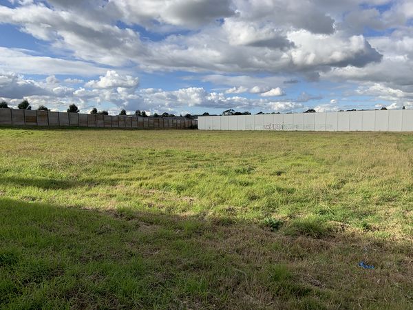
It's in the corner!
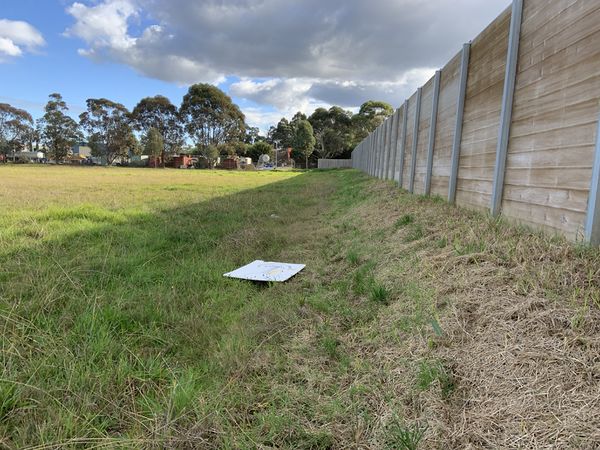
Now I'm in the corner!
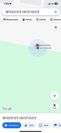
Proof


BarbaraTables earned the Land geohash achievement
|
BarbaraTables achieved level 3 of the Minesweeper Geohash achievement
|
BarbaraTables earned the Public transport geohash achievement
|
