Difference between revisions of "2024-06-29 58 5"
From Geohashing
(→Photos) |
(→Photos) |
||
| Line 38: | Line 38: | ||
Image:2024-06-29_58_5_Pica42_1719668800953.jpg|Sola [https://openstreetmap.org/?mlat=58.90301680&mlon=5.61332330&zoom=16 @58.9030,5.6133] | Image:2024-06-29_58_5_Pica42_1719668800953.jpg|Sola [https://openstreetmap.org/?mlat=58.90301680&mlon=5.61332330&zoom=16 @58.9030,5.6133] | ||
Image:20240629 58 5 W.jpg|thumb|View to the west | Image:20240629 58 5 W.jpg|thumb|View to the west | ||
| − | + | Image:20240629_58 5 S.jpg|thumb|View to the south | |
Revision as of 17:02, 29 June 2024
| Sat 29 Jun 2024 in 58,5: 58.9030150, 5.6133894 geohashing.info google osm bing/os kml crox |

Location
On a cycle path by the road between Sola and Tananger, Rogaland, Norway.
Participants
Plans
Expedition
Tracklog
Photos

Sola @58.9030,5.6133
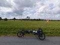
View to the west
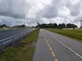
View to the south


Achievements