Difference between revisions of "2024-07-02 -37 144"
([live picture]GPS proof) |
m |
||
| (24 intermediate revisions by 5 users not shown) | |||
| Line 1: | Line 1: | ||
| − | + | {{meetup graticule|date=2024-07-02|lat=-37|lon=144}} | |
| + | == Location == | ||
| + | In some grass behind Keilor Downs Secondary College | ||
| + | |||
| + | == Participants == | ||
| + | Expedition 1: | ||
| + | *[[User:Johnwrw|John]] | ||
| + | Expedition 2: | ||
| + | *[[User:BarbaraTables|BarbaraTables]] | ||
| + | Expedition 3: | ||
| + | *[[User:Lachie|Lachie]] (Unsuccessful) | ||
| + | |||
| + | == Expedition 1 == | ||
| + | In the morning I noticed the hash was in a park 10km from home. Very gettable. Then my location adjusted slightly and the app now read that I was 9.999km from the hash. Wow, so it is exactly 10km from home. | ||
| + | |||
| + | I baked bread in the morning while having a relatively unproductive and unsatisfying morning thesis-wise. At least the bread turned out well. | ||
| + | |||
| + | After lunch I decided I had to go get the hash now as the weather was looking so fine, and work wasn't happening today anyway apparently. | ||
| + | |||
| + | I set off on my bike, then a couple of hundred metres up the road I turned back to get my little bag that straps on the front carrying basic tools and an emergency muesli bar. I was going to be riding up to Brimbank park via the river trail, which has been "closed" since the floods, due to it being in pretty poor shape. It's still very much usable, if you are happy to [https://i.kym-cdn.com/entries/icons/original/000/024/196/sign.jpg ignore] the regular signs telling you it's closed. But I thought it wise to have some capacity to deal with mechanical issues, since my bike is very much not set up for much beyond paved road. | ||
| + | |||
| + | I got down to the river, and headed away from the hash to cross at the pipe bridge, since I wasn't sure how easy it would be to cross with my bike at the rock-hopping ford (which would have been much more direct). I got soon to the closed section. It was even less closed than previous occasions I've seen it. The gate that you used to have to go up and around was open (perhaps sawn open by vigilantes?). The futile "this track is closed" signs were still there though. | ||
| + | |||
| + | Most of the recent occasions I've come here, I've been on foot, where the state of the track didn't bother me in the slightest. On a road bike, it was pretty sketchy at times. But I made it. Before too long, I was at Brimbank park. I crossed at the ford there, and climbed the steep path out of the valley up to Green Gully road. Near the top, there was a sign informing me that the ground around was contaminated with asbestos. Not what you want to see while sucking in lungfuls of air at the top of a climb. | ||
| + | |||
| + | I crossed the road at the intersection, and went into a what seemed like an interminable series of sporting facilities. I found my way through, passing signs for the German Shepherd Dog Club of Victoria Inc. Western Branch. I appreciate the clarity added by including the word "dog" in their name. They don't want Heinrich or Günter rocking up to one of their events with a crook and a flock of sheep. Eventually I got to the end of the soccer pitches etc., where it gave way onto a pretty underutilized grassy powerline reservation. However, there was a fence between me and the hash. Am I not supposed to go there? I soon realised that the fence was actually to keep rapscallions and ne'er-do-wells out of the sporting precinct I was inside of. Good. That didn't solve the issue of being on the wrong side of the fence though. I prepared to climb the fence (no barbs thankfully), before I noticed that not 10m further along, the fence just ended, and all I had to do was navigate my way through some strategically placed boulders (to at least stop the ruffians from driving vehicles through). | ||
| − | [ | + | The hash was still 300m away across the paddock. I left my bike against [https://www.youtube.com/watch?v=d_XVVCVHGlQ a nice boulder], and set off at a little jog. Soon I was there. I was just near the back fence of a high school but it is currently school holidays so the place was pretty quiet. Not quite deserted however, it seems that school holiday time is when you get the leaf blowers out for the astroturfed sporting fields. I hate leaf blowers and astroturf. |
| − | + | Anyway, I set back off and came much the same way I had gone, though this time I did attempt, successfully, the rock hopping crossing with bike at Solomon's ford and this saved me some distance and also got me onto a paved path much earlier. Soon I was home, having had a lovely mid-afternoon's ride in the sunshine. I think I saw the most red browed finches that I have ever seen on a single excursion. Flock after flock of them throughout the ride. | |
| − | |||
| − | + | === Photos === | |
| − | + | <gallery mode="packed" heights="300px"> | |
| − | == | ||
| − | < | ||
| − | + | Image:2024-07-02_-37_144_Johnwrw_1719900054735.jpg|Success | |
| − | |||
| − | |||
| − | + | Image:2024-07-02_-37_144_Johnwrw_1719900088062.jpg|Leaf blowing the astroturf | |
| − | |||
| − | + | Image:2024-07-02_-37_144_Johnwrw_1719900141525.jpg|Dog specifically | |
| − | |||
| − | + | Image:2024-07-02_-37_144_Johnwrw_1719900158065.jpg|Not up for a pat | |
| − | |||
| − | + | Image:2024-07-02_-37_144_Johnwrw_1719900194404.jpg|Doable | |
| − | |||
| − | Image:2024- | ||
| − | |||
| − | |||
Image:2024-07-02_-37_144_Johnwrw_1719900031597.jpg|GPS proof | Image:2024-07-02_-37_144_Johnwrw_1719900031597.jpg|GPS proof | ||
</gallery> | </gallery> | ||
| − | == Achievements == | + | === Achievements === |
{{#vardefine:ribbonwidth|100%}} | {{#vardefine:ribbonwidth|100%}} | ||
| − | <!-- | + | {{bicycle geohash |
| + | |date=2024-07-02 | ||
| + | |latitude=-37 | ||
| + | |longitude=144 | ||
| + | |name=[[User:Johnwrw|Johnwrw]] | ||
| + | |distance=30.6km | ||
| + | |bothways=yes | ||
| + | |image= | ||
| + | }} | ||
| + | |||
| + | == Expedition 2 == | ||
| + | |||
| + | After spending some time in Brunswick, I proceeded to the Geohash by taking the train from Jewell Station to North Melbourne Station, the train from North Melbourne Station to St. Albans Station, then the 419 bus. I didn't get the [[Public_transport_geohash_achievement|Public Transport Achievement]] however, as I took private transport to get from my home to Brunswick. | ||
| + | |||
| + | I was late for the 419 twice - first on the way there, then on the way back. Exiting St. Albans Station (which I had never been to before), I looked around for the buses. Ah, there they are! Hey, that one's got the bus route number I'm after! ...And the same direction. Oh no. | ||
| + | |||
| + | Thankfully, the bus driver noticed and let me on. | ||
| + | |||
| + | I got off, walked down the paved pathway in the field the Geohash was in, snapped some pictures, then started walking back. I nearly got to the bus stop, and what do I see? The bus I was meant to take. It comes every 18 minutes, so I had to wait that long. | ||
| + | |||
| + | <gallery mode="packed" heights="300px"> | ||
| + | File:2024-07-02_-37_144_north_melbourne_station.JPEG|Sunset at North Melbourne Station | ||
| + | File:2024-07-02_-37_144_proof.PNG|Hash proof! | ||
| + | File:2024-07-02_-37_144_selfie.JPEG|Hash selfie! | ||
| + | File:2024-07-02_-37_144_flash1.JPEG | ||
| + | File:2024-07-02_-37_144_flash2.JPEG | ||
| + | File:2024-07-02_-37_144_flash3.JPEG | ||
| + | File:2024-07-02_-37_144_flash4.JPEG | ||
| + | File:2024-07-02_-37_144_noflash1.JPEG | ||
| + | File:2024-07-02_-37_144_noflash2.JPEG | ||
| + | File:2024-07-02_-37_144_dangit.PNG|Missed it by a minute | ||
| + | </gallery> | ||
| + | |||
| + | {{land geohash | ||
| + | |||
| + | | latitude = -37 | ||
| + | | longitude = 144 | ||
| + | | date = 2024-07-02 | ||
| + | | name = [[User:BarbaraTables|BarbaraTables]] | ||
| + | |||
| + | }} | ||
| + | |||
| + | == Expedition 3 == | ||
| + | Lachie attempted this expedition but sadly fell short. He was riding to the airport to catch a plane to Vietnam and at a certain point during the night, at 7:18pm and 2.9km away from the hash, he realised that he had a difficult choice to make between reaching the hash and boarding his flight to Vietnam. | ||
| − | + | Unfortunately, he chose unwisely and went to Vietnam. | |
| − | |||
| − | |||
| − | |||
| − | < | + | <gallery mode="packed" heights="300px"> |
| − | |||
| − | |||
| − | |||
| − | + | Image:2024-07-02_-37_144_Felix Dance _1719978207683.jpg|Lachie not at the hash | |
| − | + | Image:2024-07-02_-37_144_Felix Dance _1719978221173.jpg|Closest approach | |
| − | |||
| − | |||
| − | |||
| − | -- | ||
| − | < | + | </gallery> |
| − | |||
| − | + | {{White Rabbit | |
| − | |||
| − | |||
| − | |||
| − | |||
| − | + | | latitude = -37 | |
| − | [[ | + | | longitude = 144 |
| + | | date = 2024-07-02 | ||
| + | | name = [[User:Lachie|Lachie]] | ||
| + | | image = | ||
| − | + | }} | |
| − | + | __NOTOC__ | |
| − | + | [[Category:Expeditions]] | |
| + | [[Category:Expeditions with photos]] | ||
| + | [[Category:Coordinates reached]] | ||
| + | {{location|AU|VIC|BR}} | ||
Latest revision as of 08:04, 3 July 2024
| Tue 2 Jul 2024 in -37,144: -37.7160763, 144.8140392 geohashing.info google osm bing/os kml crox |
Location
In some grass behind Keilor Downs Secondary College
Participants
Expedition 1:
Expedition 2:
Expedition 3:
- Lachie (Unsuccessful)
Expedition 1
In the morning I noticed the hash was in a park 10km from home. Very gettable. Then my location adjusted slightly and the app now read that I was 9.999km from the hash. Wow, so it is exactly 10km from home.
I baked bread in the morning while having a relatively unproductive and unsatisfying morning thesis-wise. At least the bread turned out well.
After lunch I decided I had to go get the hash now as the weather was looking so fine, and work wasn't happening today anyway apparently.
I set off on my bike, then a couple of hundred metres up the road I turned back to get my little bag that straps on the front carrying basic tools and an emergency muesli bar. I was going to be riding up to Brimbank park via the river trail, which has been "closed" since the floods, due to it being in pretty poor shape. It's still very much usable, if you are happy to ignore the regular signs telling you it's closed. But I thought it wise to have some capacity to deal with mechanical issues, since my bike is very much not set up for much beyond paved road.
I got down to the river, and headed away from the hash to cross at the pipe bridge, since I wasn't sure how easy it would be to cross with my bike at the rock-hopping ford (which would have been much more direct). I got soon to the closed section. It was even less closed than previous occasions I've seen it. The gate that you used to have to go up and around was open (perhaps sawn open by vigilantes?). The futile "this track is closed" signs were still there though.
Most of the recent occasions I've come here, I've been on foot, where the state of the track didn't bother me in the slightest. On a road bike, it was pretty sketchy at times. But I made it. Before too long, I was at Brimbank park. I crossed at the ford there, and climbed the steep path out of the valley up to Green Gully road. Near the top, there was a sign informing me that the ground around was contaminated with asbestos. Not what you want to see while sucking in lungfuls of air at the top of a climb.
I crossed the road at the intersection, and went into a what seemed like an interminable series of sporting facilities. I found my way through, passing signs for the German Shepherd Dog Club of Victoria Inc. Western Branch. I appreciate the clarity added by including the word "dog" in their name. They don't want Heinrich or Günter rocking up to one of their events with a crook and a flock of sheep. Eventually I got to the end of the soccer pitches etc., where it gave way onto a pretty underutilized grassy powerline reservation. However, there was a fence between me and the hash. Am I not supposed to go there? I soon realised that the fence was actually to keep rapscallions and ne'er-do-wells out of the sporting precinct I was inside of. Good. That didn't solve the issue of being on the wrong side of the fence though. I prepared to climb the fence (no barbs thankfully), before I noticed that not 10m further along, the fence just ended, and all I had to do was navigate my way through some strategically placed boulders (to at least stop the ruffians from driving vehicles through).
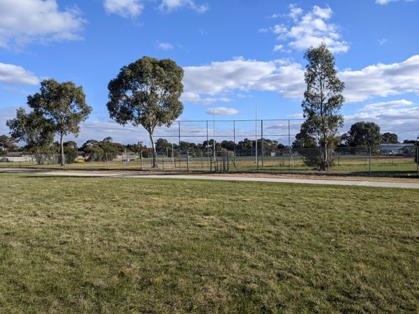
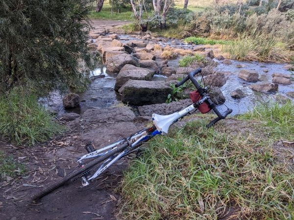
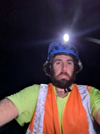
The hash was still 300m away across the paddock. I left my bike against a nice boulder, and set off at a little jog. Soon I was there. I was just near the back fence of a high school but it is currently school holidays so the place was pretty quiet. Not quite deserted however, it seems that school holiday time is when you get the leaf blowers out for the astroturfed sporting fields. I hate leaf blowers and astroturf.
Anyway, I set back off and came much the same way I had gone, though this time I did attempt, successfully, the rock hopping crossing with bike at Solomon's ford and this saved me some distance and also got me onto a paved path much earlier. Soon I was home, having had a lovely mid-afternoon's ride in the sunshine. I think I saw the most red browed finches that I have ever seen on a single excursion. Flock after flock of them throughout the ride.
Photos
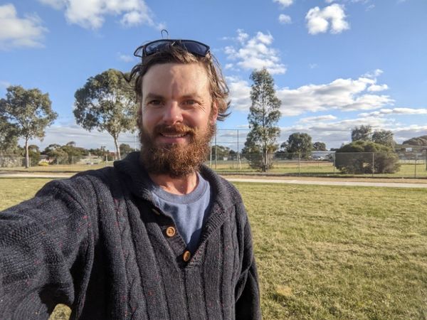
Success
Leaf blowing the astroturf
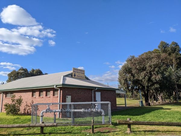
Dog specifically
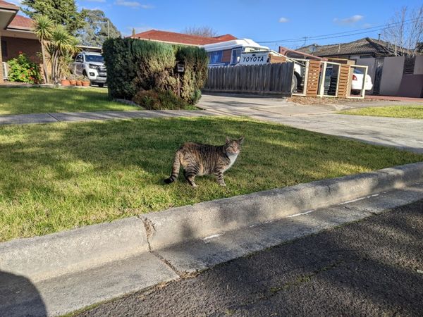
Not up for a pat
Doable
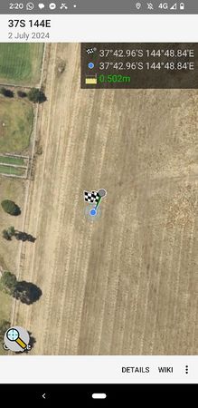
GPS proof


Achievements
Johnwrw earned the Bicycle geohash achievement
|
Expedition 2
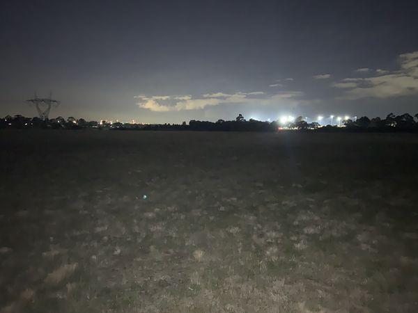
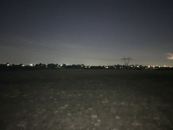
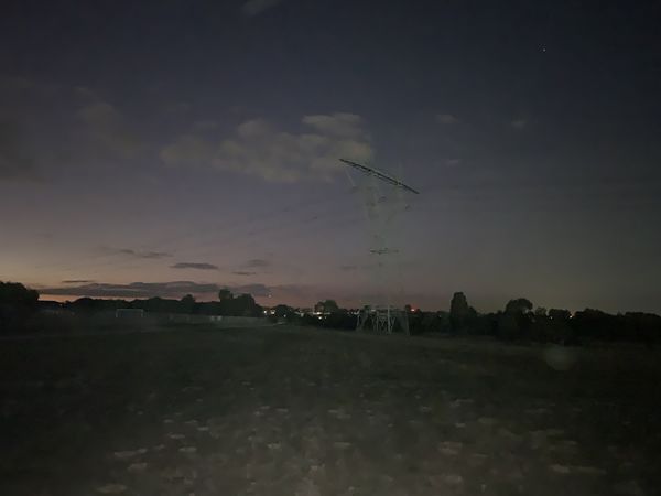
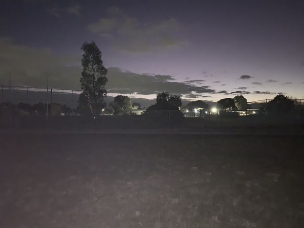
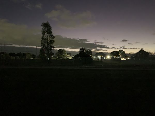
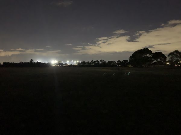
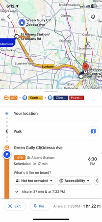
After spending some time in Brunswick, I proceeded to the Geohash by taking the train from Jewell Station to North Melbourne Station, the train from North Melbourne Station to St. Albans Station, then the 419 bus. I didn't get the Public Transport Achievement however, as I took private transport to get from my home to Brunswick.
I was late for the 419 twice - first on the way there, then on the way back. Exiting St. Albans Station (which I had never been to before), I looked around for the buses. Ah, there they are! Hey, that one's got the bus route number I'm after! ...And the same direction. Oh no.
Thankfully, the bus driver noticed and let me on.
I got off, walked down the paved pathway in the field the Geohash was in, snapped some pictures, then started walking back. I nearly got to the bus stop, and what do I see? The bus I was meant to take. It comes every 18 minutes, so I had to wait that long.
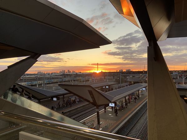
Sunset at North Melbourne Station
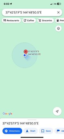
Hash proof!
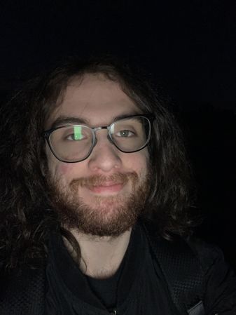
Hash selfie!
Missed it by a minute


BarbaraTables earned the Land geohash achievement
|
Expedition 3
Lachie attempted this expedition but sadly fell short. He was riding to the airport to catch a plane to Vietnam and at a certain point during the night, at 7:18pm and 2.9km away from the hash, he realised that he had a difficult choice to make between reaching the hash and boarding his flight to Vietnam.
Unfortunately, he chose unwisely and went to Vietnam.
Lachie not at the hash
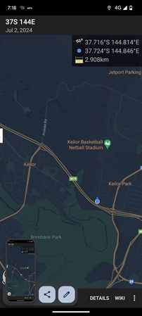
Closest approach


Lachie earned the White Rabbit consolation prize
|