| Thu 4 Jul 2024 in 43,6: 43.7894232, 6.9249340 geohashing.info google osm bing/os kml crox |
Location
In a forest next to the Loup river, near Gréolières Village, France
Participants
Plans
I noticed that this geohash was only a 500-meters walk in some relatively-easy-to-navigate-woods away from a road, so I decided to go get it.
Expedition
After driving my dad's SUV through a narrow and tortuous mountain road (why are all of today's cars so big?), we arrived as close as we could to the hash. So we parked the car, went to the other side of the road and immediately noticed a problem: there was a 10-meter drop between the road and the forest underneath. Thankfully, after some looking around, we managed to find a spot to get down in the woods easily. The only thing between us and the hashpoint was now a 500 meter walk in the forest, which wasn't that bad as gravity was on our side. Towards the end, the terrain got harder to navigate, but at this point there were only a few meters left so nothing stopped me from reaching the hash. Sadly, that was the easy part, as we now had to go back up to the road, which made it hard to see the terrain ahead and increased the difficulty of navigation, and in addition gravity had now switched sides, so we were now forced to fight against it. But none of that stopped us from getting back to the car and driving home.
Photos
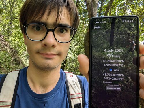
I got the hash.

Achievements
None (this puts my average at 1 achievement/expedition, which is really not that bad but I don't think I'll be able to keep this up for long)