Difference between revisions of "2024-07-05 48 7"
From Geohashing
([retro picture]Obligatory stupid grin.) |
|||
| (8 intermediate revisions by 2 users not shown) | |||
| Line 12: | Line 12: | ||
== Participants == | == Participants == | ||
| − | * [[User:LeslieHapablap|LeslieHapablap]], ([[2018-06-19 48 7|previous]]|next) | + | * [[User:LeslieHapablap|LeslieHapablap]], ([[2018-06-19 48 7|previous]]|[[2024-07-07 48 9|next]]) |
== Plans == | == Plans == | ||
| Line 19: | Line 19: | ||
== Expedition == | == Expedition == | ||
Not much to tell :) Biked to work, made a very short detour to reach the hash point. It was located in a forest area, and the mosquitos enjoyed my visit. | Not much to tell :) Biked to work, made a very short detour to reach the hash point. It was located in a forest area, and the mosquitos enjoyed my visit. | ||
| + | |||
| + | == Tracklog == | ||
| + | {{tracklog | 2024-07-05_07-14-52.gpx}} | ||
== Photos == | == Photos == | ||
| Line 26: | Line 29: | ||
<gallery perrow="5"> | <gallery perrow="5"> | ||
| − | Image:2024-07-05_48_7_LeslieHapablap_1720157901986.jpg| | + | Image:2024-07-05_48_7_LeslieHapablap_1720157901986.jpg|Obligatory proof. |
Image:2024-07-05_48_7_LeslieHapablap_1720984352015.jpg|Obligatory stupid grin. | Image:2024-07-05_48_7_LeslieHapablap_1720984352015.jpg|Obligatory stupid grin. | ||
| + | |||
| + | Image:2024-07-05_48_7_LeslieHapablap_1720984411362.jpg|A forest. | ||
</gallery> | </gallery> | ||
| + | == Other geohashing expeditions on the same day == | ||
| + | {{expedition summaries|2024-07-05}} | ||
== Achievements == | == Achievements == | ||
{{#vardefine:ribbonwidth|100%}} | {{#vardefine:ribbonwidth|100%}} | ||
| Line 52: | Line 59: | ||
}} | }} | ||
| + | {{Speedrun achievement | ||
| + | |||
| + | | latitude = 48 | ||
| + | | longitude = 7 | ||
| + | | date = 2024-07-05 | ||
| + | | minutes = 48 | ||
| + | | name = [[User:LeslieHapablap|LeslieHapablap]] | ||
| + | |||
| + | }} | ||
| + | Proof of the speedrun in the linked gpx: First track point at <nowiki><time>2024-07-05T05:15:08.149Z</time></nowiki>, last track point at <nowiki><time>2024-07-05T06:03:03.417Z</time></nowiki>. | ||
__NOTOC__ | __NOTOC__ | ||
<!-- =============== USEFUL CATEGORIES FOLLOW ================ | <!-- =============== USEFUL CATEGORIES FOLLOW ================ | ||
| Line 87: | Line 104: | ||
(Don't forget to delete this final close comment marker) --> | (Don't forget to delete this final close comment marker) --> | ||
| + | {{location|DE|BW|EM}} | ||
Latest revision as of 21:30, 14 July 2024
| Fri 5 Jul 2024 in 48,7: 48.0805176, 7.8572925 geohashing.info google osm bing/os kml crox |
Location
In a forest near Denzlingen.
Participants
Plans
I got an app alert about a nearby hash point. Indeed, it was almost directly on my route to work.
Expedition
Not much to tell :) Biked to work, made a very short detour to reach the hash point. It was located in a forest area, and the mosquitos enjoyed my visit.
Tracklog
Photos
Obligatory proof.
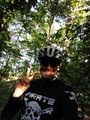
Obligatory stupid grin.
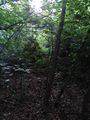
A forest.


Other geohashing expeditions on the same day
Expeditions and Plans
| 2024-07-05 | ||
|---|---|---|
| Genève, Switzerland | Someone went | Vallon de Tenneverge, Sixt-Fer-à-Cheval, France In case anyone is planning... |
| Strasbourg, France | LeslieHapablap | In a forest near Denzlingen. |
| Northampton, United Kingdom | PeterRoder | A lane leading to a farm near Cosgrove, on the outskirts of Milton Keynes |
Achievements
LeslieHapablap earned the Land geohash achievement
|
LeslieHapablap earned the Bicycle geohash achievement
|
LeslieHapablap earned the Speedrun achievement
|
Proof of the speedrun in the linked gpx: First track point at <time>2024-07-05T05:15:08.149Z</time>, last track point at <time>2024-07-05T06:03:03.417Z</time>.