Difference between revisions of "2024-07-07 48 9"
From Geohashing
(→Tracklog) |
(→Achievements) |
||
| Line 40: | Line 40: | ||
== Achievements == | == Achievements == | ||
{{#vardefine:ribbonwidth|100%}} | {{#vardefine:ribbonwidth|100%}} | ||
| − | <!-- | + | == Achievements == |
| + | {{#vardefine:ribbonwidth|100%}} | ||
| + | {{land geohash | ||
| + | |||
| + | | latitude = 48 | ||
| + | | longitude = 9 | ||
| + | | date = 2024-07-07 | ||
| + | | name = [[User:LeslieHapablap|LeslieHapablap]] | ||
| + | |||
| + | }} | ||
| + | {{Walk geohash | ||
| + | | latitude = 48 | ||
| + | | longitude = 9 | ||
| + | | date = 2024-07-07 | ||
| + | | name = [[User:LeslieHapablap|LeslieHapablap]] | ||
| + | }} | ||
| + | |||
| + | __NOTOC__ | ||
| + | <!-- =============== USEFUL CATEGORIES FOLLOW ================ | ||
| + | Delete the next line ONLY if you have chosen the appropriate categories below. If you are unsure, don't worry. People will read your report and help you with the classification. --> | ||
| + | [[Category:Expeditions]] | ||
| + | [[Category:Expeditions with photos]] | ||
| + | [[Category:Coordinates reached]] | ||
| + | |||
__NOTOC__ | __NOTOC__ | ||
Revision as of 20:32, 14 July 2024
| Sun 7 Jul 2024 in 48,9: 48.9964317, 9.5292088 geohashing.info google osm bing/os kml crox |
Location
On a field near Bartenbach.
Participants
- LeslieHapablap, (previous|next)
Plans
Expedition
Tracklog
Photos

Hashpoint reached!
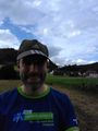
Obligatory stupid grin
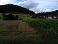
The hash point
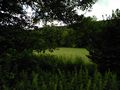
Looking the other direction


Achievements
Achievements
LeslieHapablap earned the Land geohash achievement
|
LeslieHapablap earned the Walk geohash Achievement
|