Difference between revisions of "2024-07-07 48 9"
From Geohashing
(→Plans) |
(→Achievements) |
||
| Line 56: | Line 56: | ||
| name = [[User:LeslieHapablap|LeslieHapablap]] | | name = [[User:LeslieHapablap|LeslieHapablap]] | ||
}} | }} | ||
| + | {{Speedrun achievement | ||
| + | |||
| + | | latitude = 48 | ||
| + | | longitude = 9 | ||
| + | | date = 2024-07-07 | ||
| + | | minutes = 45 | ||
| + | | name = [[User:LeslieHapablap|LeslieHapablap]] | ||
| + | }} | ||
| + | Proof of the speedrun in the linked GPX: first track point at <nowiki><time>2024-07-07T16:35:04.097Z</time> | ||
| + | </nowiki>, last track point at <nowiki><time>2024-07-07T17:19:57.258Z</time> | ||
| + | </nowiki>. | ||
__NOTOC__ | __NOTOC__ | ||
Revision as of 21:03, 14 July 2024
| Sun 7 Jul 2024 in 48,9: 48.9964317, 9.5292088 geohashing.info google osm bing/os kml crox |
Location
On a field near Bartenbach.
Participants
- LeslieHapablap, (previous|next)
Plans
Run there, then run back.
Expedition
Tracklog
Photos

Hashpoint reached!
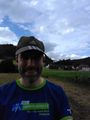
Obligatory stupid grin
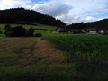
The hash point
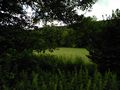
Looking the other direction


Achievements
Achievements
LeslieHapablap earned the Land geohash achievement
|
LeslieHapablap earned the Walk geohash Achievement
|
LeslieHapablap earned the Speedrun achievement
|
Proof of the speedrun in the linked GPX: first track point at <time>2024-07-07T16:35:04.097Z</time> , last track point at <time>2024-07-07T17:19:57.258Z</time> .