Difference between revisions of "2024-07-07 64 25"
(Created page with "{{subst:expedition}}") |
|||
| (2 intermediate revisions by 2 users not shown) | |||
| Line 1: | Line 1: | ||
| − | + | {{meetup graticule|date=2024-07-07|lat=64|lon=25}} | |
| + | == Location == | ||
| + | In a meadow near Svaaninsuo, Oulu. | ||
| − | [ | + | The point on a topographic map: [https://kripakko.neocities.org/geohash_maplink?{{#replace:{{SUBPAGENAME}}| |_}}K] |
| − | + | == Participants == | |
| − | + | * [[User:Kripakko|Kripakko]] | |
| + | * Kripakko’s fiancée | ||
| − | + | == Expedition == | |
| − | + | This point happened to be about two kilometres from home, and I just had to get to it. | |
| − | + | I considered a few options and ended up wanting to [[Bicycle geohash achievement|cycle]] | |
| − | + | to the point [[Midnight Geohash|at midnight]]. | |
| + | At the first midnight (0:00) we were busy and it was raining like crazy, | ||
| + | so the second midnight (24:00) was the only practical option. | ||
| + | It was cloudy and windy with a temperature of about 16 °C. | ||
| + | The sun would set at 23:53 according to [https://www.timeanddate.com/sun/finland/oulu timeanddate.com] and [https://sunrisesunsetmap.com sunrisesunsetmap.com] | ||
| + | or at 23:54 according to [http://www.clearskyinstitute.com/xephem XEphem] and [https://www.suncalc.org/#/64.9964,25.5292,12/2024.07.07/23:54/0/0 SunCalc.org], | ||
| + | and there would be practically full daylight throughout the night. | ||
| − | + | We went together and would also pay a quick visit to a 24/7 grocery store while we were out. | |
| − | + | We made our way to the vicinity of the hashpoint and stopped on the cycleway about 25 metres from it. | |
| − | + | The meadow was not as easy to traverse as I had hoped as tall grasses were growing densely in it. | |
| + | I could have walked through them but would not have been able to see what I was stepping on, | ||
| + | so I walked back a little and found a route where the vegetation was not as dense. | ||
| + | There were lots of mosquitoes and potentially [https://en.wikipedia.org/wiki/Ixodes_ricinus ticks]. | ||
| + | While I was there, Fiancée waited by the cycleway. | ||
| − | = | + | I had a stupid moment with technology when I tried to record proof. |
| − | + | I had many tabs open in the web browser and I did not want to close them all, | |
| + | and so I had opened [https://kripakko.neocities.org/qdgn QDGN] | ||
| + | in a private tab so that the open tabs would not be visible in screenshots. | ||
| + | I waited until the time was 23:59:55 or so and took a screenshot, | ||
| + | hoping to show that I was here in the end of the day. | ||
| + | However, I did not know that screenshots of Vivaldi private tabs are blanked out by default! | ||
| + | Because of that, I did not get the screenshot that I wanted. | ||
| + | I then [https://www.youtube.com/watch?v=nDP1KvHWuUI cursed loudly] a little, | ||
| + | closed all browser tabs and reloaded GDQN in a normal tab. | ||
| + | In the process, I lost the cached tracklog (makes sense in hindsight that it's only kept within the private tab), | ||
| + | so I had to import the backup that I had saved before taking the selfie and then continued recording. | ||
| + | At least I have proof in the tracklog that I reached the point before and after midnight, | ||
| + | but a chunk of data around midnight is missing (see lines 1220–1223 in the GPX). | ||
| + | So, you will have to take my word for having just stood still during that time. | ||
| + | I finally took a screenshot of QDGN which shows my location after midnight. | ||
| − | + | I then walked back to the cycleway, and we began cycling again towards the grocery store. | |
| − | + | I determined afterwards that we cycled about 9.4 kilometres in total. | |
| + | I had got several mosquito bites but thankfully no ticks. | ||
== Tracklog == | == Tracklog == | ||
| − | + | {{tracklog|2024-07-07_64_25_tracklog.gpx}} | |
== Photos == | == Photos == | ||
| − | < | + | <gallery perrow="3"> |
| − | Image:2024- | + | Image:2024-07-07_64_25_01-bicycle.jpg|My bicycle parked by the cycleway, about 25 metres to go towards the big birch. |
| − | -- | + | Image:2024-07-07_64_25_02-selfie.jpg|Stupid Grin™ at the hash­point. The tall grasses really were more than a metre tall. Coincidentally, the sun set at the same time, at 23:54. |
| − | + | Image:2024-07-07_64_25_03-qdgn.png|Screenshot of [https://kripakko.neocities.org/qdgn QDGN] after midnight when the active hashpoint had changed. I was still in the coordinates of this geohash. | |
</gallery> | </gallery> | ||
== Achievements == | == Achievements == | ||
| − | {{ | + | {{land geohash |
| − | + | | latitude=64 | |
| + | | longitude=25 | ||
| + | | date=2024-07-07 | ||
| + | | name=[[User:Kripakko|Kripakko]] | ||
| + | }} | ||
| + | {{bicycle geohash | ||
| + | | latitude=64 | ||
| + | | longitude=25 | ||
| + | | date=2024-07-07 | ||
| + | | name=[[User:Kripakko|Kripakko]] | ||
| + | | distance=9.4 km | ||
| + | | bothways=true | ||
| + | }} | ||
| + | {{midnight geohash | ||
| + | | latitude=64 | ||
| + | | longitude=25 | ||
| + | | date=2024-07-07 | ||
| + | | name=[[User:Kripakko|Kripakko]] | ||
| + | }} | ||
| − | |||
| − | |||
| − | |||
| − | |||
| − | |||
| − | |||
| − | |||
| − | |||
| − | |||
| − | |||
| − | |||
[[Category:Expeditions]] | [[Category:Expeditions]] | ||
| − | |||
[[Category:Expeditions with photos]] | [[Category:Expeditions with photos]] | ||
| − | |||
| − | |||
| − | |||
| − | |||
[[Category:Coordinates reached]] | [[Category:Coordinates reached]] | ||
| − | + | {{location|FI|14}} | |
| − | |||
| − | |||
| − | |||
| − | |||
| − | |||
| − | |||
| − | |||
| − | |||
| − | |||
| − | |||
| − | |||
| − | |||
| − | |||
Revision as of 08:48, 8 July 2024
| Sun 7 Jul 2024 in 64,25: 64.9964317, 25.5292088 geohashing.info google osm bing/os kml crox |
Location
In a meadow near Svaaninsuo, Oulu.
The point on a topographic map: [1]
Participants
- Kripakko
- Kripakko’s fiancée
Expedition
This point happened to be about two kilometres from home, and I just had to get to it. I considered a few options and ended up wanting to cycle to the point at midnight. At the first midnight (0:00) we were busy and it was raining like crazy, so the second midnight (24:00) was the only practical option. It was cloudy and windy with a temperature of about 16 °C. The sun would set at 23:53 according to timeanddate.com and sunrisesunsetmap.com or at 23:54 according to XEphem and SunCalc.org, and there would be practically full daylight throughout the night.
We went together and would also pay a quick visit to a 24/7 grocery store while we were out. We made our way to the vicinity of the hashpoint and stopped on the cycleway about 25 metres from it. The meadow was not as easy to traverse as I had hoped as tall grasses were growing densely in it. I could have walked through them but would not have been able to see what I was stepping on, so I walked back a little and found a route where the vegetation was not as dense. There were lots of mosquitoes and potentially ticks. While I was there, Fiancée waited by the cycleway.
I had a stupid moment with technology when I tried to record proof. I had many tabs open in the web browser and I did not want to close them all, and so I had opened QDGN in a private tab so that the open tabs would not be visible in screenshots. I waited until the time was 23:59:55 or so and took a screenshot, hoping to show that I was here in the end of the day. However, I did not know that screenshots of Vivaldi private tabs are blanked out by default! Because of that, I did not get the screenshot that I wanted. I then cursed loudly a little, closed all browser tabs and reloaded GDQN in a normal tab. In the process, I lost the cached tracklog (makes sense in hindsight that it's only kept within the private tab), so I had to import the backup that I had saved before taking the selfie and then continued recording. At least I have proof in the tracklog that I reached the point before and after midnight, but a chunk of data around midnight is missing (see lines 1220–1223 in the GPX). So, you will have to take my word for having just stood still during that time. I finally took a screenshot of QDGN which shows my location after midnight.
I then walked back to the cycleway, and we began cycling again towards the grocery store. I determined afterwards that we cycled about 9.4 kilometres in total. I had got several mosquito bites but thankfully no ticks.
Tracklog
Photos
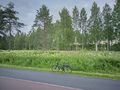
My bicycle parked by the cycleway, about 25 metres to go towards the big birch.
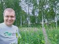
Stupid Grin™ at the hashpoint. The tall grasses really were more than a metre tall. Coincidentally, the sun set at the same time, at 23:54.
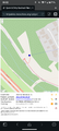
Screenshot of QDGN after midnight when the active hashpoint had changed. I was still in the coordinates of this geohash.


Achievements
Kripakko earned the Land geohash achievement
|
Kripakko earned the Bicycle geohash achievement
|
Kripakko earned the Midnight Geohash achievement
|