Difference between revisions of "2024-07-13 65 25"
m |
|||
| (4 intermediate revisions by 2 users not shown) | |||
| Line 9: | Line 9: | ||
== Expedition == | == Expedition == | ||
| − | + | I had already planned a cycling trip to the | |
| − | + | [https://www.geocaching.com/geocache/GCAA3ZX Mega-Event Geocache] in Ii today, | |
| − | [https://www.geocaching.com/geocache/GCAA3ZX Mega-Event Geocache] in Ii. | + | and this hashpoint happened to be in the same general direction. |
| + | The point itself was easily accessible, | ||
| + | but it would require a long diversion along bad roads | ||
| + | and add more than an hour of travel time. | ||
| + | Seemed reasonable enough! | ||
| + | I already knew the nearest road from [[2024-04-21 65 25]] | ||
| + | when I drove past (at time [https://youtu.be/eQqzFRID2SA?t=3963 1:06:03] on the video). | ||
| + | Had the point been on or next to the road, | ||
| + | this would have been an indisputable [[Déjà Vu Geohash]]. | ||
| + | The weather today was partly cloudy, and the temperature was around 20 °C. | ||
| − | + | I left from home and followed cycleways via Haukipudas to Ii. | |
| − | + | Outside of having to go round a construction site in Tuira, | |
| − | + | I could easily follow the main cycleways. | |
| − | + | After about two hours, I arrived at the event location, | |
| − | + | stayed there for about half an hour and then began cycling back. | |
| + | I took a gravel road towards the hashpoint, | ||
| + | and it turned into an uneven forest road with lots of rocks and puddles. | ||
| + | Here I hoped that I had ridden my mountain bike, | ||
| + | but the hybrid bike with narrow tyres worked well enough. | ||
| + | Eventually, the road got better again, | ||
| + | and I got on the past route of [[2024-04-21 65 25]]. | ||
| + | |||
| + | The open logging area was not exactly open any more | ||
| + | as many grasses and saplings were growing in it. | ||
| + | I could just barely follow the logging road that was marked in the map | ||
| + | and park the bicycle next to the hashpoint. | ||
| + | I had to take pictures and leave quickly | ||
| + | because I was attacked by mosquitoes and [https://en.wikipedia.org/wiki/Tabanidae horseflies] | ||
| + | and got nasty bites fast. | ||
| + | I also fully expected to grab some [https://en.wikipedia.org/wiki/Ixodes_ricinus ticks] from there, | ||
| + | but thankfully I did not find any on myself afterwards. | ||
| + | |||
| + | I made my way to Haukipudas and then followed the cycleways back to the city centre of Oulu. | ||
| + | A part of the route was going to be closed due to a music festival on Kuusisaari island, | ||
| + | so I took a different route via other islands. | ||
| + | I parked the bicycle to the city centre and, | ||
| + | being hungry after cycling a hundred kilometres and eating next to nothing during the day, | ||
| + | treated myself to a big buffet dinner. | ||
| + | Then I cycled home and finally got to rest. | ||
| + | According to the GPS receiver, the length of the trip was 103.9 km, | ||
| + | of which I walked 0.2 km and cycled 103.7 km. | ||
== Tracklog == | == Tracklog == | ||
| Line 26: | Line 61: | ||
2024-07-13_65_25_01-road1.jpg|Highway 847 (old highway 4) towards Ii. | 2024-07-13_65_25_01-road1.jpg|Highway 847 (old highway 4) towards Ii. | ||
2024-07-13_65_25_02-event.jpg|At the geocaching mega-event. | 2024-07-13_65_25_02-event.jpg|At the geocaching mega-event. | ||
| − | 2024-07-13_65_25_03-road2.jpg|Not too promising traffic signs, but I should be able to proceed by bicycle. | + | 2024-07-13_65_25_03-road2.jpg|Not too promising traffic signs (private road, dead end, no turning space for road trains, weight-limited bridge), but I should be able to proceed by bicycle. |
| − | 2024-07-13_65_25_04-road3.jpg| | + | 2024-07-13_65_25_04-road3.jpg|The forest road at its worst. The puddles were not very deep but still annoying enough that I did my best to avoid them. |
| − | 2024-07-13_65_25_05-bilberries.jpg|Bilberries | + | 2024-07-13_65_25_05-bilberries.jpg|Bilberries (''Vaccinium myrtillus'') were ripening but still barely edible at best. |
| − | 2024-07-13_65_25_06-road4.jpg|Better road once again, from this point on familiar from | + | 2024-07-13_65_25_06-road4.jpg|Better road once again, from this point on familiar from [[2024-04-21 65 25]] (at time [https://youtu.be/eQqzFRID2SA?t=3810 1:03:30] on the video). |
| − | 2024-07-13_65_25_07-road5.jpg|Final | + | 2024-07-13_65_25_07-road5.jpg|Final logging road towards the hashpoint, about 100 metres to go. |
2024-07-13_65_25_08-bicycle.jpg|Bicycle parked next to the hashpoint. I was just barely able to ride all the way. | 2024-07-13_65_25_08-bicycle.jpg|Bicycle parked next to the hashpoint. I was just barely able to ride all the way. | ||
2024-07-13_65_25_09-gpsr1.jpg|Hashpoint reached, proof of location. | 2024-07-13_65_25_09-gpsr1.jpg|Hashpoint reached, proof of location. | ||
2024-07-13_65_25_10-gpsr2.jpg|Proof of date and time. | 2024-07-13_65_25_10-gpsr2.jpg|Proof of date and time. | ||
2024-07-13_65_25_11-selfie.jpg|Selfie at the hashpoint. | 2024-07-13_65_25_11-selfie.jpg|Selfie at the hashpoint. | ||
| − | 2024-07-13_65_25_12-lingonberries.jpg|Lingonberries | + | 2024-07-13_65_25_12-lingonberries.jpg|Lingonberries (''Vaccinium vitis-idaea'') were still raw and should ripen by September. |
| − | 2024-07-13_65_25_13-road6.jpg| | + | 2024-07-13_65_25_13-road6.jpg|Gravel road with a rough surface and occasional annoyingly big rocks. |
2024-07-13_65_25_14-river.jpg|The Kiiminkijoki river. | 2024-07-13_65_25_14-river.jpg|The Kiiminkijoki river. | ||
</gallery> | </gallery> | ||
| Line 57: | Line 92: | ||
__NOTOC__ | __NOTOC__ | ||
| − | |||
| − | |||
| − | |||
| − | |||
| − | |||
| − | |||
| − | |||
| − | |||
| − | |||
[[Category:Expeditions]] | [[Category:Expeditions]] | ||
| − | |||
[[Category:Expeditions with photos]] | [[Category:Expeditions with photos]] | ||
| − | |||
| − | |||
| − | |||
| − | |||
[[Category:Coordinates reached]] | [[Category:Coordinates reached]] | ||
| − | + | {{location|FI|14}} | |
| − | |||
| − | |||
| − | |||
| − | |||
| − | |||
| − | |||
| − | |||
| − | |||
| − | |||
| − | |||
| − | |||
| − | |||
| − | |||
Latest revision as of 19:25, 22 July 2024
| Sat 13 Jul 2024 in 65,25: 65.2166294, 25.5512527 geohashing.info google osm bing/os kml crox |
Location
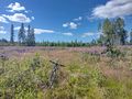
In an open logging area near Onkamo, Haukipudas, Oulu.
The point on a topographic map: [1]
Participants
Expedition
I had already planned a cycling trip to the Mega-Event Geocache in Ii today, and this hashpoint happened to be in the same general direction. The point itself was easily accessible, but it would require a long diversion along bad roads and add more than an hour of travel time. Seemed reasonable enough! I already knew the nearest road from 2024-04-21 65 25 when I drove past (at time 1:06:03 on the video). Had the point been on or next to the road, this would have been an indisputable Déjà Vu Geohash. The weather today was partly cloudy, and the temperature was around 20 °C.
I left from home and followed cycleways via Haukipudas to Ii. Outside of having to go round a construction site in Tuira, I could easily follow the main cycleways. After about two hours, I arrived at the event location, stayed there for about half an hour and then began cycling back. I took a gravel road towards the hashpoint, and it turned into an uneven forest road with lots of rocks and puddles. Here I hoped that I had ridden my mountain bike, but the hybrid bike with narrow tyres worked well enough. Eventually, the road got better again, and I got on the past route of 2024-04-21 65 25.
The open logging area was not exactly open any more as many grasses and saplings were growing in it. I could just barely follow the logging road that was marked in the map and park the bicycle next to the hashpoint. I had to take pictures and leave quickly because I was attacked by mosquitoes and horseflies and got nasty bites fast. I also fully expected to grab some ticks from there, but thankfully I did not find any on myself afterwards.
I made my way to Haukipudas and then followed the cycleways back to the city centre of Oulu. A part of the route was going to be closed due to a music festival on Kuusisaari island, so I took a different route via other islands. I parked the bicycle to the city centre and, being hungry after cycling a hundred kilometres and eating next to nothing during the day, treated myself to a big buffet dinner. Then I cycled home and finally got to rest. According to the GPS receiver, the length of the trip was 103.9 km, of which I walked 0.2 km and cycled 103.7 km.
Tracklog
Photos
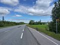
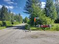
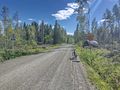
Highway 847 (old highway 4) towards Ii.
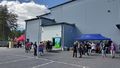
At the geocaching mega-event.
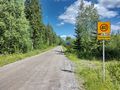
Not too promising traffic signs (private road, dead end, no turning space for road trains, weight-limited bridge), but I should be able to proceed by bicycle.
The forest road at its worst. The puddles were not very deep but still annoying enough that I did my best to avoid them.
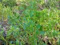
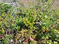
Bilberries (Vaccinium myrtillus) were ripening but still barely edible at best.
Better road once again, from this point on familiar from 2024-04-21 65 25 (at time 1:03:30 on the video).
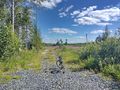
Final logging road towards the hashpoint, about 100 metres to go.
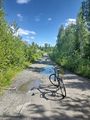
Bicycle parked next to the hashpoint. I was just barely able to ride all the way.
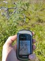
Hashpoint reached, proof of location.
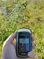
Proof of date and time.
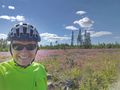
Selfie at the hashpoint.
Lingonberries (Vaccinium vitis-idaea) were still raw and should ripen by September.
Gravel road with a rough surface and occasional annoyingly big rocks.

The Kiiminkijoki river.


Achievements
Kripakko earned the Land geohash achievement
|
Kripakko earned the Bicycle geohash achievement
|