2024-09-16 56 -4
| Mon 16 Sep 2024 in 56,-4: 56.0499639, -4.4767641 geohashing.info google osm bing/os kml crox |
Contents
Location
In a field near Croftamie.
Participants
Plans
KerrMcF
I'll drive to the nearby village of Croftamie and park somewhere before walking along a path/track to the field itself. There seems to be a clear path through the field leading close to the point, so I'll follow this. I should be able to reach the point quite easily from there. The drive there should take about 20 minutes, and the walk should take another 30. Overall, the expedition should take about 1hr 45m.
Expedition
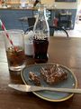
The drive to Croftamie was pretty much just along one road for about 20 minutes. The best place to park was at The But & Ben café, but I felt like I couldn't just park there without buying something. I went into the café and bought a Diet Coke and a rocky road, which were both good. When paying, I asked the server if it would be fine to leave the car in the car park for an hour while I went on a walk, to which the answer was yes.
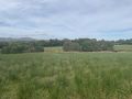
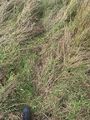
I left the café car park just after 3pm and began my walk towards the field. It was mostly along a quiet single-track road, and I didn't have much difficulty getting there. The field itself had two entrances. After the first gate, there was a flattened path through the grass, leading diagonally in the general direction of the geohash. I could see that it wouldn't lead directly to the geohash, and that it was further away than the next gate, so I decided to continue on to see what the second entrance looked like. Although it was closer, gate two did not have a flattened path at all. Instead, the field on the other side was just grass from the gate to the geohash. It wasn't too bad, though, and I decided that going this way would be better than heading back to take the flattened path, which may not even lead to the geohash.
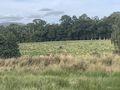
As I climbed over the gate, I noticed some cows a little further on than the location of the geohash. I wasn't able to tell whether they were in the same field or not, but they hadn't seen me yet, and I was going to try my best not to disturb them. I continued through the field, watching my step, and noticed two deer in the area of the geohash. I couldn't see them by that point, as they were in the trees somewhere, so I didn't take a photo. As I got closer to the geohash, the cows all turned to watch me. They didn't look aggressive in any way, so I wasn't worried, but I made sure not to move at a quick pace to avoid spooking them.
Eventually I reached the geohash with the cows still watching and took my usual photos. Whilst I was doing so, the two deer ran across in front of me to a different area. The cows and I turned to watch as they did so, but they were too fast for me to take a photo. I said goodbye to the cows and began heading back to the car. The walk back was along the same route, and it was very simple. I passed by a few wild berries - Scotland tends to be very good for the hunter-gatherer achievement - but I didn't eat any, as I'm not fully confident in my ability to determine what is safe to eat. I reached the car and drove back home along the same road I took to get there. The expedition took place from 2:15pm to around 4:20pm. This is my third consecutive success, all of which have been in different graticules. Click for 56,-3 or 55,-3.
Photos
Quick break at the café
View from the field entrance
Being watched
Reached the geohash
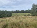
Zoomed out view
The geohash itself
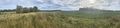
Panorama taken from the geohash
Still being watched
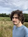
Me (and the cows) at the geohash

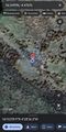
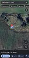
The walking route


Achievements
KerrMcF earned the Land geohash achievement
|
KerrMcF earned the Consecutive geohash achievement
|
Progress
| Council Area | Postcode | NUTS | Centicule |
|---|---|---|---|
| Stirling | G(63) | UKM77 | 04 |
| Expedition Navigation | ||
|---|---|---|
| KerrMcF's expeditions | Next | |