2024-09-15 55 -3
| Sun 15 Sep 2024 in 55,-3: 55.9435660, -3.9466165 geohashing.info google osm bing/os kml crox |
Contents
Location
In a field near Palacerigg Country Park.
Participants
Plans
KerrMcF
I'll drive to Palacerigg Country Park's car park and walk through the golf course to reach the point. OpenStreetMap suggests that the point is located within a bog, but the land looks relatively okay from satellite imagery and a drone photo on streetview. I'll make sure to bring boots, just in case the ground is unpleasant.
Expedition
KerrMcF
I left volunteering shortly after 2pm and drove to Palacerigg Country Park. Whilst I was driving into the entrance of the park, it began to rain very heavily. I'd brought a jacket with me, so I was prepared for this weather, but it wasn't looking great. After parking, I began my walk to the geohash. The rain stopped almost immediately, which was nice, but it meant that for my entire expedition, I was wearing a fleece and a winter jacket in direct sun. Not the best attire for the weather, but not much can be done about that when it was raining right before I started walking.
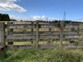
The geohash was in a fenced-off field, and I initially struggled to find the gate. After searching for a while, I found the entrance gate next to a fence with the phrase "woe be upon ye" sprayed onto it. This felt like an omen of what was to come, and it sort of was. The geohash was at the other end of the field from the gate, and between me and the geohash was 120m of thick, wet grass. I tried for a couple of minutes to navigate through this, but quickly realised I needed another way into the field.
After leaving the field and doubling back on myself, I found a part of the fence that had mostly collapsed. I stepped over this, which brought me closer to the area of the geohash, and walked along the edge of the field to get to a clearing. From this clearing, I found the point nearest the geohash, and re-entered the thick grass. There was a semi-clear route to the geohash from this point, and I reached it fairly quickly. I took my photos and retraced my steps back to the car. The drive home was simple as well, and it was mostly along the same route I took to get there.
Photos
Bad omen
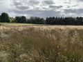
Thick grass
Fallen fence

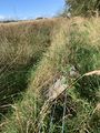
Reached the geohash
Zoomed out view
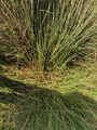
The geohash itself
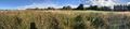
Panorama from the geohash

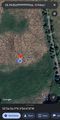
My walking route


Achievements
KerrMcF earned the Land geohash achievement
|
KerrMcF earned the Consecutive geohash achievement
|
Progress
| Council Area | Postcode | NUTS | Centicule |
|---|---|---|---|
| North Lanarkshire | G(67) | UKM84 | 99 |
| Expedition Navigation | ||
|---|---|---|
| KerrMcF's expeditions | No Next Yet | |