2024-09-14 53 7
| Sat 14 Sep 2024 in 53,7: 53.0513396, 7.9321299 geohashing.info google osm bing/os kml crox |
Location
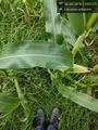
On a corn field near Wolfstange.
Participants
Plans
Since the distance between my home and the geohash was shown as slightly more than 18 km I planned to go there by bike and gave myself about 90 minutes, considering the road layout was not exactly the same as the proverbial crow's flight path. I also set out for a Tron achievement, planning to go a different route on the way home.
Expedition
Starting at roughly 14:30, I didnt make it in time to the geohash but arrived at 16:30. This was due to some bad ad hoc routing decisions and to my refusal to backtrack when I became aware of them, because I didn't want to sacrifice the Tron achievement. The first leg of the journey was dominated by using a quite novel cycle highway (Fahrradstraße).
Tracklog

There are gaps in the track when my phone couldn't get a satellite fix. In the direct vicinity of the geohash I had to use the same path in both directions but I painstakingly avoided crossing my own path.
Photos
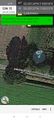
Proof @53.0514,7.9322
On the site of the geohash.
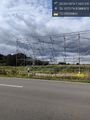
Installation scaffold for a new high voltage line. @53.1072,8.0881
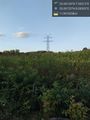
Something is missing here. @53.0972,8.0934


Achievements