2024-10-13 43 -78
| Sun 13 Oct 2024 in 43,-78: 43.0049865, -78.8765568 geohashing.info google osm bing/os kml crox |
Location
Edge of Summit St in the City of Tonawanda
Participants
Expedition
When the hashes were published on Friday, I thought I could ride my bike to this in the morning and then head to Allegany State Park in the Buffalo Graticule for a Double hash. In the morning, I checked the weather and it was supposed to rain ALL day across the region, mostly fluctuating between 20 and 50% chance each hour. Noting that the early afternoon had less chance of rain, I packed a lunch and headed to this hash first around 11:00.
It was a quick and easy one following the Phone GPS. Getting to the hash-street, I pulled over and hopped out to walk over to the hash. It was quick work on the HashDroid App and after getting a couple pictures of the area, I got back in the car and plugged in the Buffalo Hash for directions. Google expected me to arrive around 13:00.
Photos

Made it.

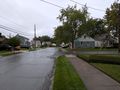
View East from the hash.

View South, across the street where I parked.
View West.

Standard Stupid Grin.

Back in the car, a view of the Hash area and the hash-house.


Ribbons
This user earned the Land geohash achievement
|