2024-10-13 42 -78
| Sun 13 Oct 2024 in 42,-78: 42.0049865, -78.8765568 geohashing.info google osm bing/os kml crox |
Location
Allegany State Park off the North Country Trail near Wolf Run Rd
Participants
Expedition
After a quick stop in the City of Tonawanda, I was on my way to ASP. It was a mostly normal ride until I got to the end of the highway portion of Rt 219 where the cars on the other side were backed up about 1.5 miles/2 KM and I thought that was really weird. Fortunately, my side was flowing pretty well and I had no delays. That is until I got to Ellicottville and realized it was FallFest which explained the backup earlier. Even with the rain all day, the little ski-town was packed. I took a quick detour (that no one else seemed to be taking) to avoid Main St and got around pretty easily and got back to the 219 in no time (probably saved at LEAST 10 min). From there, it was an easy drive the rest of the way to Wolf Run Road.
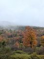
The first part of the road is paved, but little used so it's starting to get grown over on the sides so it's sorta down to 1.5 lanes where it used to be 2. The rain had mostly stopped at this point, but the clouds were really low and there was fog drifting above the forest and in the valleys of the hills. The trees have really started turning so I stopped and got a couple pictures as well where I had a nice valley view. Getting to the end of the paved portion, the gate was open and the dirt road looked passable so I continued. There were some giant potholes filled with water, but nothing my car couldn't handle and I was able to make it to the end and very close to the hash. As I was turning the car around to park, I saw a Ring-necked Pheasant in the brush.
I turned on the GPS and could have gone straight to the hash, but there were signs of Beaver all over the place. I didn't want to get caught in marshy land so I took the trail that continued on Wolf Run Road (at this point is just a shadow of a road with a hiking trail down the middle) which shortly led me to the North Country Trail. This took me pretty close to the hash, but I was thinking it was to the right of the trail, so I ended up walking past it and when the numbers started rising again, I took out my phone and pulled up the HashDroid App. I didn't have a signal, but it did pick up my location and confirmed I had walked past it. Back to the closest spot on the trail, I started into the woods and along a stream that was running nearby and heading toward the hash. Getting close, the GPS was jumping around a bit so I used both the GPS and HashDroid App to shorten the GPS dance before I got too frustrated walking in circles. I managed to get a good reading on the GPS and got some pictures before heading back to the trail. Still with plenty of time left, I set a short timer and continued on the trail for a while. At my turnaround point, I spooked a White-tail deer but I whistled at him and got him to stop. I saw he had a couple points on his antlers and I got a picture of him before he jumped away again.
On the drive home, I set an alternate route to avoid Ellicottville and the traffic situation over there and made it home without any issues where I had pizza for dinner. What a great day!
Photos
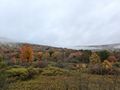
On Wolf Run Road, a small vista across the little valley.
The leaves are starting to change.
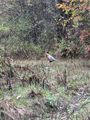
Parking the car, I saw this phesant.
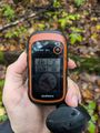
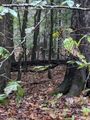
Made it to the hash.
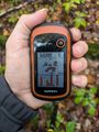
Accuracy.
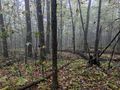
View Northish, from where I walked in.
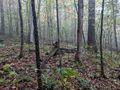
View West from the hash.
View South.
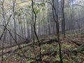
View East.

Standard Stupid Grin.
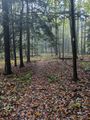
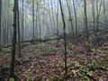
Back on the trail for some extra hiking.
The White Tail buck right after turning around to head back to the car.


Ribbons
This user earned the Land geohash achievement
|
Pedalpusher earned the Multihash Achievement
|