Difference between revisions of "User:Juventas"
imported>Juventas (add latest) |
imported>Juventas m |
||
| Line 69: | Line 69: | ||
|[[Mabel Lake, British Columbia|Mabel Lake]] | |[[Mabel Lake, British Columbia|Mabel Lake]] | ||
|[[User:DigitalAngel|DigitalAngel]] | |[[User:DigitalAngel|DigitalAngel]] | ||
| − | | | + | |~5km :p |
| | | | ||
|- | |- | ||
Revision as of 09:24, 7 February 2009
I geohash in the Vernon, British Columbia and Mabel Lake, British Columbia graticules. It's a great place to be if you like to get to the middle of nowhere. Unfortunately it also means there's no other geohashers around.
Getting Around
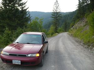
I drive a Subaru Legacy, which is a great car for all the unpaved roads here. It doesn't always cut it on the logging roads and four-wheeler trails, which are required traveling for most hash points. Nevertheless, I think I surprise some of the pickups passing by, and sometimes myself. I had been considering a dual-sport motorcycle, and since geohashing I want one even more!
Photography
I enjoy photography, and geohashing gave me the last push to purchasing a digital SLR. My photos taken up till the August 28th hash are with a point & shoot, and those after should be with the SLR. If you ever want a print-quality copy please let me know, I'd be flattered.
Getting in Touch
Feel free to leave anything on my discussion page. Also, I sometimes can be found in the #geohashing channel on Foonetic.
Expeditions
| 2008-07-26 | Vernon | solo | ~150m | Near the northern tip of Okanagan Lake, in a reed bed. |
| 2008-08-09 | Vernon | solo | ~200m | Near one of the Specs Lakes, on the swampy shoreline. |
| 2008-08-16 | Vernon | solo | ~600m | Far north of Bouleau Lake, in a dense forest. |
| 2008-08-23 | Vernon | solo | reached | Near Tadpole Lake, in a logging clearing. |
| 2008-08-30 | Vernon | Jing | reached | sorta |
| 2008-08-31 | Mabel Lake | solo | reached | |
| 2008-09-14 | Surrey | DigitalAngel | reached | |
| 2008-10-11 | Vernon | family | reached | |
| 2009-01-18 | Mabel Lake | DigitalAngel | ~5km :p | |
| 2009-01-25 | Vernon | DigitalAngel | reached |
