Difference between revisions of "2008-09-22 -35 138"
From Geohashing
imported>Karcean (New page: {{meetup graticule | map=<map lat="-35" lon="138" date="2008-09-18" /> | lat=-35 | lon=138 | date=2008-09-22 }} == Location == The geohash on the 22nd of September 2008 for the Southern ...) |
imported>Thomcat (Success/failure category added) |
||
| Line 21: | Line 21: | ||
Image:080922-35_138_03.jpg|More wet muddy track I thankfully didn't need to trudge on. | Image:080922-35_138_03.jpg|More wet muddy track I thankfully didn't need to trudge on. | ||
Image:080922-35_138_04.jpg|The little proof I have of doing the Geo# point.</gallery> | Image:080922-35_138_04.jpg|The little proof I have of doing the Geo# point.</gallery> | ||
| + | |||
| + | [[Category:Expeditions]] | ||
| + | [[Category:Expeditions with photos]] | ||
| + | [[Category:Coordinates reached]] | ||
| + | [[Category:Expedition without GPS]] | ||
Revision as of 14:10, 29 September 2008
| Mon 22 Sep 2008 in -35,138: -35.2867028, 138.9586847 geohashing.info google osm bing/os kml crox |
Location
The geohash on the 22nd of September 2008 for the Southern Graticule of Adelaide . Located just out of Strathalbyn. I was hoping to meet other Geohashers but sadly i was the only one.
I didn't bring a Camera or my GPS unit because my new Nokia N95 does both. Not thinking it through I set out but when I got to the Geo# point I found that taking a photo of my GPS unit as proof i was there was next to imposable. :-(
People
- Nathan all on his own.
Other Photos
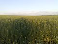
unwilling to charge out into the field I took a photo of where the geohash is.
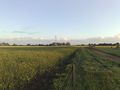
This is the wet muddy track I trudged up to this point.
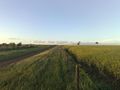
More wet muddy track I thankfully didn't need to trudge on.
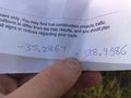
The little proof I have of doing the Geo# point.


