Difference between revisions of "2008-10-08 -33 150"
From Geohashing
imported>CJ (Created expedition) |
imported>CJ (→Photos: Finally uploaded the pics) |
||
| Line 28: | Line 28: | ||
==Photos== | ==Photos== | ||
Coming soon. | Coming soon. | ||
| − | + | <gallery> | |
| − | Image: | + | Image:CJ_054.JPG|The nearby street corner |
| − | + | Image:CJ_055.JPG|CJ at the hash point | |
| − | Image: | + | </gallery> |
| − | </gallery | ||
[[Category:Expeditions]] | [[Category:Expeditions]] | ||
[[Category:Expeditions with photos]] | [[Category:Expeditions with photos]] | ||
[[Category:Coordinates reached]] | [[Category:Coordinates reached]] | ||
Revision as of 06:02, 25 October 2008
| Wed 8 Oct 2008 in -33,150: -33.7698993, 150.9606956 geohashing.info google osm bing/os kml crox |
Contents
Location
This geohash location looked like it was going to be an easy one - and it was. The exact location was on some grass right next to the footpath at the corner of Madonna St and Ayles Rd in Winston Hills - a quiet suburb in Sydney's North-West.
Attendees
CJ earned the Land geohash achievement
|
Report
Coming soon.
Photos
Coming soon.
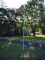
The nearby street corner

CJ at the hash point

