Difference between revisions of "2008-10-29 49 8"
From Geohashing
imported>Ilpadre (→Location) |
imported>Ilpadre (→ilpadre) |
||
| Line 13: | Line 13: | ||
== Expedition== | == Expedition== | ||
===[[User:ilpadre|ilpadre]]=== | ===[[User:ilpadre|ilpadre]]=== | ||
| − | Planning: | + | Planning: This will be a [[Déjà Vu Geohash]] for me. <br> |
| + | Proof: The hashpoint is right next to a footpath I've been on before: | ||
| + | |||
| + | [[Image:Riesensteinpfad.jpg|500px]] | ||
| + | |||
| + | The following two pictures were taken exactly one month ago, at 14:36 and 15:26. The first was taken next to the ''Riesensteinpfad'', the second standing before the ''Friedrich-Ebert-Platz''. The only footpath connecting those places and is the one with the hashpoint next to it. | ||
| + | |||
| + | <gallery> | ||
| + | Image:IMG_1150.jpg | ||
| + | Image:IMG_1157.jpg | ||
| + | </gallery> | ||
Revision as of 15:43, 28 October 2008
| Wed 29 Oct 2008 in Mannheim: 49.4069810, 8.7007491 geohashing.info google osm bing/os kml crox |
Location
Today's hashpoint is located about 400 m South of Heidelberg's tourist-attracting Hauptstraße. It is the third hashpoint to fall within Heidelberg city limits in just one week, all within a radius of less than 3 km (see also 2008-10-26 49 8 and 2008-10-22 49 8). Chances of this happening are about 1:3500 for this graticule.
Expedition
ilpadre
Planning: This will be a Déjà Vu Geohash for me.
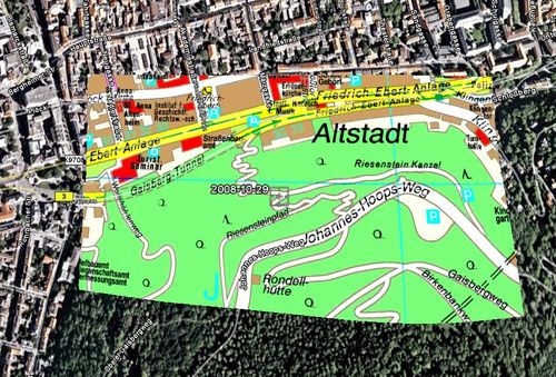
Proof: The hashpoint is right next to a footpath I've been on before:
The following two pictures were taken exactly one month ago, at 14:36 and 15:26. The first was taken next to the Riesensteinpfad, the second standing before the Friedrich-Ebert-Platz. The only footpath connecting those places and is the one with the hashpoint next to it.


