2008-10-26 49 8
| Sun 26 Oct 2008 in Mannheim: 49.3791181, 8.7210166 geohashing.info google osm bing/os kml crox |
Location
Today's hashpoint is located in the Odenwald, near Heidelberg, at an altitude of 462 m.
Expedition
ilpadre
Planning: Again, the hashpoint is reachable by foot, though it will be more difficult this time. A footpath through the woods is about 40 m away from the hashpoint. I don't own a GPS device, but I'm confident that I’ll find the spot.
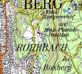
Topographic map with hashpoint marker
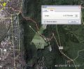
Planned route


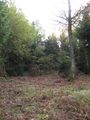
Expedition: The hashpoint was about 1 km from the Max Planck Institute for Nuclear Physics (where I've been several times) and also not far from one of my favorite running tracks. The weather was nice, so I put on my running gear and started. It was a fun run, but I had to take a minor detour from my planned route. I reached the footpath from where I had to go through the woods after about 50 minutes. Then I spent 20 minutes looking for the exact spot, using the configuration of trees and other landscape elements for orientation. There was a small artificial clearing with a deer stand not far from the hashpoint, and on the way to the hash I discovered a place with lots of what Germans call Hallimasche - delicious mushrooms and a good reason to return with big bags next year. The word Hallimasch means "greasy ass" (Middle High German "hal im arsch") because they are laxative when eaten raw. I also found incredible masses of Waldmeister ("master of the woods"). English speakers know it as woodruff.
ilpadre earned the Walk geohash Achievement
|
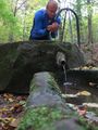
Refreshing spring water
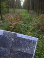
Getting closer
And when we have reached to the highest of all / The gradations of growth our minds shall recall / So that link by link we may join them together / And trace step by step the way we reached thither
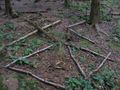
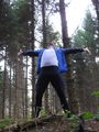
Hashmark inspired by relet
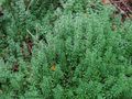
Galium odoratum
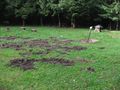
Clearing
Deer stand


