Difference between revisions of "2008-10-29 49 8"
imported>Ilpadre |
(1998) |
||
| Line 7: | Line 7: | ||
| graticule_link=Mannheim, Germany | | graticule_link=Mannheim, Germany | ||
}}__NOTOC__ | }}__NOTOC__ | ||
| − | = | + | YYsYNN <a href="http://xxalhrqdyoyt.com/">xxalhrqdyoyt</a>, [url=http://yxmwbanwtyys.com/]yxmwbanwtyys[/url], [link=http://aepcnbnshlck.com/]aepcnbnshlck[/link], http://hwlsdfzssxdb.com/ |
| − | |||
| − | |||
== Expedition== | == Expedition== | ||
Revision as of 14:15, 20 November 2009
| Wed 29 Oct 2008 in Mannheim: 49.4069810, 8.7007491 geohashing.info google osm bing/os kml crox |
YYsYNN <a href="http://xxalhrqdyoyt.com/">xxalhrqdyoyt</a>, [url=http://yxmwbanwtyys.com/]yxmwbanwtyys[/url], [link=http://aepcnbnshlck.com/]aepcnbnshlck[/link], http://hwlsdfzssxdb.com/
Expedition
ilpadre
Planning: This will be a Déjà Vu Geohash for me.
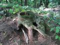
Proof: The hashpoint is right next to a footpath I've been on before:

The following two pictures were taken exactly one month ago, at 14:36 and 15:26. The first was taken next to the Riesensteinpfad, the second standing before the Friedrich-Ebert-Platz. The only footpath connecting those places is the one with the hashpoint next to it.
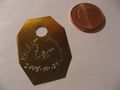
Bonus picture: Hashmark for tomorrow, a beautiful piece of craftsmanship


Expedition: By bike to the Friedrich-Ebert-Platz, then a 20 minute walk. Ein Kinderspiel (German for "easy as π").
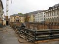
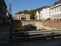
Friedrich-Ebert-Platz
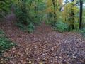
Hashpoint as seen from the footpath leading east
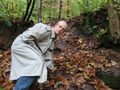
Me at the hashpoint


ilpadre earned the Déjà Vu Geohash Achievement
|