Difference between revisions of "2008-12-23 52 6"
imported>Arvid (Failed expedition.) |
imported>FippeBot m (Location) |
||
| (One intermediate revision by one other user not shown) | |||
| Line 42: | Line 42: | ||
[[Category:Expeditions with photos]] | [[Category:Expeditions with photos]] | ||
[[Category:Coordinates not reached]] | [[Category:Coordinates not reached]] | ||
| − | [[Category: | + | [[Category:Not reached - Mother Nature]] |
| + | {{location|NL|OV}} | ||
Latest revision as of 01:06, 8 August 2019
| Tue 23 Dec 2008 in 52,6: 52.2407210, 6.9617616 geohashing.info google osm bing/os kml crox |
Plan
Arvid first thought about a midnight hash, but at 23:30 he noticed it was foggy as usual, and decided to do it the day after, after work.
It looked like after stopping at the closest road as if I could walk along a bit of bushes at the edge of a field, and then the last part in a bit of woods.
Achievements
- Arvid cycled 16.5km
- Mother nature's bitch
Expedition
Arvid's tracklog by bicycle.
About 17:25 I left from work, since I had a chat with a co-worker about recumbents. It was dark, and very humid, but not raining. Just foggy. Again. Still.
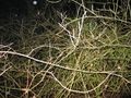
At about 17:50 I arrived at the point on the road where I intended to get off the bike and walk to the hashpoint. This field was no field of grass. It had a lot of young trees in it, very close to eachother, with brambles between them. Not very easy to get through. After 5 minutes I had done 36m. Still 254m to the hash. This is not the way.
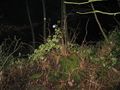
I went back, and tried to go through the woods instead of the field. This was way more successful. I did >100m in 3m30. But found more bramblebushes after that. My socks were wet. The ground was wet and full of wet leaves. So it was slippery too. I decided this was enough. In daylight I'd try from more sides, but on a cold(4°C) wet evening... no.
At 18:20 I left for home, arriving there at 18:40.
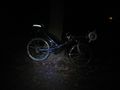
The bike.
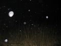
The "field"
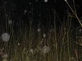
Good lucking getting through.
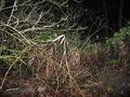
And this was the end of try 2.
And this.
And this.
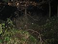
And this.


