Difference between revisions of "2008-12-27 36 -78"
From Geohashing
imported>Ncbears |
imported>Joannac m (land geohash achievement) |
||
| Line 14: | Line 14: | ||
==Achievements== | ==Achievements== | ||
<gallery widths="100px" align=center> | <gallery widths="100px" align=center> | ||
| − | Image:Landgeohash.png|[[Land | + | Image:Landgeohash.png|[[Land Geohash]] |
Image:Cherry2.PNG|[[Virgin Graticule]] | Image:Cherry2.PNG|[[Virgin Graticule]] | ||
</gallery> | </gallery> | ||
Revision as of 22:20, 28 December 2008
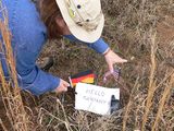
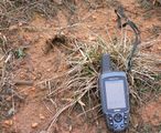
| Sat 27 Dec 2008 in 36,-78: 36.5988770, -78.0776342 geohashing.info google osm bing/os kml crox |
Bear and Eisen ventured above Gaston Lake, stopping at a few geocaches along the way. Satellite recon via Google Earth proved less than accurate because we found the geohash point seemingly blocked with a row of new houses. Calls to Pope AFB and Norfolk Naval Base yielded no SR-71 flyovers to provide updated entry approach intel. But, fortunately, one lot to the side was still for sale, so we proceeded as if interested buyers, worked our way through the thorns to the elusive empty field in the rear, and found the 36 -78 geohash point. Several deer footy prints suggested we were not the first to reach the location this day.
Participants
Achievements


Pictures
Hello distant kinfolk
Missed deer meetup
Geomoo


