Difference between revisions of "2009-01-01 36 -75"
From Geohashing
imported>Ncbears (New page: {{meetup graticule | map=<map lat="36" lon="-75" date="2009-01-01" /> | lat=36 | lon=-75 | date=2009-01-01 }} ==Report== Bear and Eisen will attempt sunrise geohash. ==Participants== Eis...) |
imported>Ncbears |
||
| Line 8: | Line 8: | ||
Bear and Eisen will attempt sunrise geohash. | Bear and Eisen will attempt sunrise geohash. | ||
| − | == | + | ==Geological Features== |
| + | Rolling farmland. Geohash in open field with low brush, grass, thorns. | ||
| − | + | ==Wildlife Encounters== | |
| + | Signs - Whitetail deer prints (see picture below), domestic dog prints. | ||
| + | |||
| + | Sighting - Domestic dog across road from parking spot barked at us. | ||
| + | |||
| + | ==Weather== | ||
| + | 50°F/10°C, Overcast, Light wind | ||
| + | |||
| + | ==Achievements== | ||
| + | <gallery widths="100px" align=center> | ||
| + | Image:Landgeohash.png|[[Land Geohash]] | ||
| + | Image:Cherry2.PNG|[[Virgin Graticule]] | ||
| + | </gallery> | ||
| + | |||
| + | ==Pictures== | ||
| + | |||
| + | <gallery widths="160px" align=center> | ||
| + | Image:12_27_08_Geohashing_N36_W78.jpg|Hello distant kinfolk | ||
| + | Image:12_27_08_Geocaching_Deer_Paws_023.jpg|Missed deer meetup | ||
| + | Image:12_27_08_Geocaching_On_the_Way.jpg|Geomoo on the way | ||
| + | </gallery> | ||
| + | |||
| + | [[Category:Expeditions]] | ||
| + | [[Category:Expeditions with photos]] | ||
| + | [[Category:Coordinates reached]] | ||
Revision as of 20:27, 1 January 2009
| Thu 1 Jan 2009 in 36,-75: 36.3784381, -75.8331568 geohashing.info google osm bing/os kml crox |
Report
Bear and Eisen will attempt sunrise geohash.
Geological Features
Rolling farmland. Geohash in open field with low brush, grass, thorns.
Wildlife Encounters
Signs - Whitetail deer prints (see picture below), domestic dog prints.
Sighting - Domestic dog across road from parking spot barked at us.
Weather
50°F/10°C, Overcast, Light wind
Achievements


Pictures
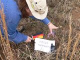
Hello distant kinfolk
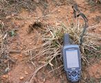
Missed deer meetup
Geomoo on the way


