Difference between revisions of "2009-02-11 66 21"
imported>The ru (New page: {{meetup graticule | map=<map lat="66" lon="21" date="2009-02-11" /> | lat=66 | lon=21 | date=2009-02-11 }} The hashpoint was 60 m from the Purnu-Nattavaara road in the Gällivare municipa...) |
imported>The ru m (wrong link) |
||
| Line 17: | Line 17: | ||
No, really, I walked/crawled through the waist-deep snow to reach the hash. I should be declared insane, but I made it. | No, really, I walked/crawled through the waist-deep snow to reach the hash. I should be declared insane, but I made it. | ||
| − | I would have taken some amazing pictures of the moonlit forest, but I fail at photography. I'm not sure how cold it was - the thermometer I bought recently seems to be displaying incorrect values (which leads me to suspect it was really much colder at my [[2009-02- | + | I would have taken some amazing pictures of the moonlit forest, but I fail at photography. I'm not sure how cold it was - the thermometer I bought recently seems to be displaying incorrect values (which leads me to suspect it was really much colder at my [[2009-02-08 67 20]] hash, but there isn't a lot to do about that now). |
I'm usually only passing through this area, so I made some short detours to check out nearby places of interest. I was home by midnight. | I'm usually only passing through this area, so I made some short detours to check out nearby places of interest. I was home by midnight. | ||
Revision as of 07:28, 12 February 2009
| Wed 11 Feb 2009 in 66,21: 66.8650157, 21.1767613 geohashing.info google osm bing/os kml crox |
The hashpoint was 60 m from the Purnu-Nattavaara road in the Gällivare municipality.
the ru
- Distance travelled: 339 km
- Reindeers almost collided with: 2
I started out around 7 PM. The two hour drive to the hash was completely uneventful. I passed through the usual places along E10. Now, there are two roads connecting the village of Purnu with E10. On the way there I took the northern route (passing through Sadjem and some other places I don't remember the names of), on the way back the northeastern.
I didn't bring any skis on this expedition, so when the GPS reported the hash being 59 m from the road, I thought "close enough" and called it a night.
No, really, I walked/crawled through the waist-deep snow to reach the hash. I should be declared insane, but I made it.
I would have taken some amazing pictures of the moonlit forest, but I fail at photography. I'm not sure how cold it was - the thermometer I bought recently seems to be displaying incorrect values (which leads me to suspect it was really much colder at my 2009-02-08 67 20 hash, but there isn't a lot to do about that now).
I'm usually only passing through this area, so I made some short detours to check out nearby places of interest. I was home by midnight.
the ru earned the Land geohash achievement
|
4 second shutter time

At the hash
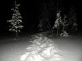
Geohasher tracks

Camera on top of the car, long shutter time


