Difference between revisions of "2009-03-28 37 -121"
From Geohashing
(→Achievements) |
imported>Ilya (→Photographic Evidence) |
||
| Line 25: | Line 25: | ||
Image:HenryCoeSun.jpg | The location! | Image:HenryCoeSun.jpg | The location! | ||
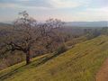
Image:2009-03-28_37_-121_HenryCoeTarget.JPG | Scenery at the destination. | Image:2009-03-28_37_-121_HenryCoeTarget.JPG | Scenery at the destination. | ||
| + | Image:HenryCoePanorama.jpg | A panoramic view. | ||
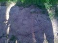
Image:2009-03-28_37_-121_HenryCoeXKCD2.JPG | Spelling out XKCD. | Image:2009-03-28_37_-121_HenryCoeXKCD2.JPG | Spelling out XKCD. | ||
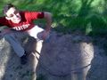
Image:HenryCoeXKCDShadows.jpg | Success! | Image:HenryCoeXKCDShadows.jpg | Success! | ||
Revision as of 07:32, 3 April 2009
| Sat 28 Mar 2009 in 37,-121: 37.2044679, -121.5471750 geohashing.info google osm bing/os kml crox |
Location
At the eastern tip of the Henry W. Coe State Park, with a beautiful hike to and fro.
People
Jason
The Tale
Ilya, Jason, & Sam's tale: We're all students at Stanford and decided it would be fun to go out for dim sum and then go geohashing. I was a bit of a drive, but quite an excellent place to visit. We got there around 4:00 p.m., took some pictures, and spelled out XKCD with pieces of sticks. On the hike back to the car, we met Graham, easily identifiable by his XKCD shirt -- nice.
Photographic Evidence
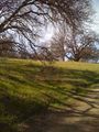
The location!
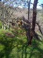
Scenery at the destination.
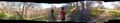
A panoramic view.
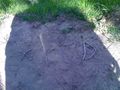
Spelling out XKCD.
Success!
Win.
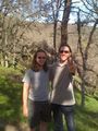
Ilya and Jason
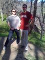
Jason and Sam
The hike back.


Achievements
ilya and Sam earned the Land geohash achievement
|

by paying to access the (37, -121) geohash on 2009-03-28.