Difference between revisions of "2009-04-28 32 -90"
From Geohashing
imported>Uglystick (New page: {{meetup graticule | lat=32 | lon=-90 | date=2009-04-28 | graticule_name=Jackson, MS | graticule_link=Jackson, Mississippi}} == About == The sixth geohash for my home graticule was pretty...) |
imported>Uglystick |
||
| Line 13: | Line 13: | ||
<gallery> | <gallery> | ||
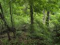
| + | Image:2009-04-28-N32-W90-1.jpg|Driving to within 20m of the point was easy | ||
| + | Image:2009-04-28-N32-W90-2.jpg|Getting down the slope of the last 20m was not | ||
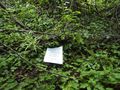
Image:2009-04-28-N32-W90-3.jpg|The point was in a bed of poison ivy | Image:2009-04-28-N32-W90-3.jpg|The point was in a bed of poison ivy | ||
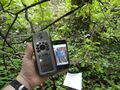
| + | Image:2009-04-28-N32-W90-4.jpg|We're within GPS accuracy - it's a hashed point! | ||
</gallery> | </gallery> | ||
[[Category:Expeditions with photos]] | [[Category:Expeditions with photos]] | ||
[[Category:Coordinates reached]] | [[Category:Coordinates reached]] | ||
Revision as of 16:56, 29 April 2009
| Tue 28 Apr 2009 in Jackson, MS: 32.2375398, -90.8303430 geohashing.info google osm bing/os kml crox |
About
The sixth geohash for my home graticule was pretty simple - a mere 5 km from my house. A quick, easy geohash I could snag on the way home from work - or so I thought.
Expedition
I was able to drive almost all the way to the point. The last 20 meters, however, were much more difficult.
- 2009-04-28-N32-W90-1.jpg
Driving to within 20m of the point was easy
Getting down the slope of the last 20m was not
The point was in a bed of poison ivy
We're within GPS accuracy - it's a hashed point!


