Difference between revisions of "2008-06-02 35 -97"
From Geohashing
imported>Benjw (creating page for ninja "expedition") |
imported>Benjw m (corrections) |
||
| Line 1: | Line 1: | ||
{{meetup graticule | {{meetup graticule | ||
| − | | lat= | + | | lat=35 |
| − | | lon=- | + | | lon=-97 |
| − | | date=2008-06- | + | | date=2008-06-02 |
| graticule_name=Oklahoma City | | graticule_name=Oklahoma City | ||
| graticule_link=Oklahoma City, Oklahoma | | graticule_link=Oklahoma City, Oklahoma | ||
| Line 9: | Line 9: | ||
<gallery> | <gallery> | ||
| − | + | Image:06-02-2008 35 -97.jpg|The approximate area of the hashpoint, taken from the road. | |
</gallery> | </gallery> | ||
[[Category:Coordinates not reached]] | [[Category:Coordinates not reached]] | ||
[[Category:Not reached - Time constraints]] | [[Category:Not reached - Time constraints]] | ||
Revision as of 08:54, 3 May 2009
| Mon 2 Jun 2008 in Oklahoma City: 35.5095264, -97.5215912 geohashing.info google osm bing/os kml crox |
Drive-by by Dani in Crown Heights Park in Oklahoma City, Oklahoma. Crown Heights is an historic preservation district in Oklahoma City. The closest road approach is about 55m from the hashpoint.
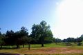
The approximate area of the hashpoint, taken from the road.
