Difference between revisions of "2009-05-10 57 11"
From Geohashing
imported>Jonatan m (→Achievements) |
imported>Jonatan |
||
| Line 14: | Line 14: | ||
== Expedition == | == Expedition == | ||
| − | |||
| − | |||
| − | |||
| Line 28: | Line 25: | ||
{{Picnic_geohash | latitude = 57 | longitude = 11 | date = 2009-05-10 | name = [[User:Jonatan|Jonatan]] and [[User:Gabriel|Gabriel]] | image = 2009-05-10-4.jpg}} | {{Picnic_geohash | latitude = 57 | longitude = 11 | date = 2009-05-10 | name = [[User:Jonatan|Jonatan]] and [[User:Gabriel|Gabriel]] | image = 2009-05-10-4.jpg}} | ||
| − | + | == Photos == | |
<gallery perrow="3"> | <gallery perrow="3"> | ||
Image:2009-05-10-2.jpg | Gabriel | Image:2009-05-10-2.jpg | Gabriel | ||
Revision as of 21:46, 10 May 2009

| Sun 10 May 2009 in 57,11: 57.9003955, 11.8551485 geohashing.info google osm bing/os kml crox |
Participants
Expedition
Photos
Achievements
Jonatan and Gabriel earned the Land geohash achievement
|
Jonatan and Gabriel earned the Bicycle geohash achievement
|
Jonatan and Gabriel earned the Picnic achievement
|
Photos

Gabriel
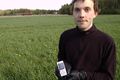
Jonatan
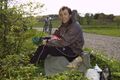
Picnic


