Difference between revisions of "File:Geohash24thMay2009.jpg"
From Geohashing
imported>Felix Dance (This is the Gmaps Pedometer image of the location of the Geohash location for 2009-05-25 -37 144. The red line shows the rough expedition of Felix Dance on foot layered on top of the Google Maps satellite image.) |
imported>Felix Dance |
||
| Line 1: | Line 1: | ||
| − | This is the Gmaps Pedometer image of the location of the Geohash location for [[2009-05-25 -37 144]]. The red line shows the rough expedition of [[Felix Dance|Felix Dance]] on foot layered on top of the Google Maps satellite image. | + | This is the Gmaps Pedometer image of the location of the Geohash location for [[2009-05-25 -37 144]]. The red line shows the rough expedition of [[Felix Dance|Felix Dance]] on foot layered on top of the Google Maps satellite image. The geohash location is near at the top right of the kilometre-stone marked "53" |
Revision as of 06:46, 25 May 2009
This is the Gmaps Pedometer image of the location of the Geohash location for 2009-05-25 -37 144. The red line shows the rough expedition of Felix Dance on foot layered on top of the Google Maps satellite image. The geohash location is near at the top right of the kilometre-stone marked "53"
File history
Click on a date/time to view the file as it appeared at that time.
| Date/Time | Thumbnail | Dimensions | User | Comment | |
|---|---|---|---|---|---|
| current | 15:21, 30 January 2020 | 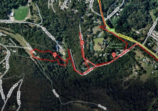 | 543 × 381 (62 KB) | Maintenance script (talk | contribs) |
- You cannot overwrite this file.
File usage
The following page links to this file: