Difference between revisions of "2009-06-17 42 -72"
imported>Sara (created expedition page) |
imported>Sara m (Adding photo) |
||
| Line 1: | Line 1: | ||
<!-- If you did not specify these parameters in the template, please substitute appropriate things for IMAGE, LAT, LON, and DATE (YYYY-MM-DD format) --> | <!-- If you did not specify these parameters in the template, please substitute appropriate things for IMAGE, LAT, LON, and DATE (YYYY-MM-DD format) --> | ||
| − | + | [[Image:{{{image|2009_06_17_42_-72_grin_sd.jpg}}}|thumb|left]] | |
| − | [[Image:{{{image| | ||
| − | |||
{{meetup graticule | {{meetup graticule | ||
| lat=42 | | lat=42 | ||
| Line 22: | Line 20: | ||
A geohash in a parking lot is an easy one to find without a GPS because it's possible to orient via the parking spaces and islands, which are visible in Google Satellite View. We drove over there and found the site pretty easily, and the kids marked the parking lot with chalk. The site has two somewhat interesting older buildings, which are now condemned, as well as the newer building which is still in use. | A geohash in a parking lot is an easy one to find without a GPS because it's possible to orient via the parking spaces and islands, which are visible in Google Satellite View. We drove over there and found the site pretty easily, and the kids marked the parking lot with chalk. The site has two somewhat interesting older buildings, which are now condemned, as well as the newer building which is still in use. | ||
| + | |||
| + | On the way there, we found an instance of a fast food restaurant that we like but that has very few instances in this area, so we stopped there for lunch on the way back. One could look at it as bribery, or as teaching the children that geohshing is a way to discover fun things. | ||
== Photos == | == Photos == | ||
| − | |||
<gallery perrow="3"> | <gallery perrow="3"> | ||
| − | Image: | + | Image:2009_06_17_42_-72_grin_sd.jpg | The kids stood at the hashpoint and grinned. It's interesting that there was a crack in the pavement right there. |
| − | |||
</gallery> | </gallery> | ||
| Line 36: | Line 34: | ||
[[Category:Expedition without GPS]] | [[Category:Expedition without GPS]] | ||
[[Category:Coordinates reached]] | [[Category:Coordinates reached]] | ||
| − | |||
| − | |||
| − | |||
| − | |||
| − | |||
| − | |||
| − | |||
[[Category:Expeditions with photos]] | [[Category:Expeditions with photos]] | ||
| − | |||
| − | |||
| − | |||
| − | |||
| − | |||
| − | |||
| − | |||
| − | |||
| − | |||
| − | |||
| − | |||
| − | |||
| − | |||
| − | |||
| − | |||
| − | |||
Revision as of 00:36, 6 July 2009

| Wed 17 Jun 2009 in 42,-72: 42.1205605, -72.5465435 geohashing.info google osm bing/os kml crox |
Location
In the parking lot of a nursing home/rehabilitation center (the former Springfield Hospital) in Springfield Massachusetts
Participants
Sara with her daughter and son
Expedition
A geohash in a parking lot is an easy one to find without a GPS because it's possible to orient via the parking spaces and islands, which are visible in Google Satellite View. We drove over there and found the site pretty easily, and the kids marked the parking lot with chalk. The site has two somewhat interesting older buildings, which are now condemned, as well as the newer building which is still in use.
On the way there, we found an instance of a fast food restaurant that we like but that has very few instances in this area, so we stopped there for lunch on the way back. One could look at it as bribery, or as teaching the children that geohshing is a way to discover fun things.
Photos
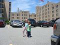
The kids stood at the hashpoint and grinned. It's interesting that there was a crack in the pavement right there.