Difference between revisions of "2009-06-23 52 6"
imported>Arvid (let's see if i still know how to do this...) |
imported>FippeBot m (Location) |
||
| (One intermediate revision by one other user not shown) | |||
| Line 23: | Line 23: | ||
<gallery> | <gallery> | ||
| + | Image:2009-06-23 52 6-RES03137.JPG|The bike. | ||
| + | Image:2009-06-23 52 6-RES04138.JPG|The man, sucking. | ||
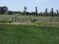
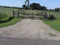
| + | Image:2009-06-23 52 6-RES03139.JPG|The open gate. | ||
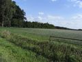
| + | Image:2009-06-23 52 6-RES03140.JPG|The to-be-trampled-grass. | ||
| + | Image:2009-06-23 52 6-RES03141.JPG|Coordinates reached. | ||
| + | Image:2009-06-23 52 6-RES04142.JPG|Happy hasher. | ||
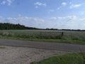
| + | Image:2009-06-23 52 6-RES03143.JPG|View to the bike from the hashpoint. | ||
| + | Image:2009-06-23 52 6-RES03144.JPG|View from the road to the hashpoint. | ||
| + | Image:2009-06-23 52 6-RES04145.JPG|Time&date. | ||
| + | Image:2009-06-23 52 6-RES03146.JPG|Tag. | ||
| + | Image:2009-06-23 52 6-RES03147.JPG|Tag left, bike right. | ||
| + | Image:2009-06-23 52 6-RES03148.JPG|Tag in the front, hashpoint in the back. | ||
</gallery> | </gallery> | ||
| Line 29: | Line 41: | ||
[[Category:Expeditions with photos]] | [[Category:Expeditions with photos]] | ||
[[Category:Coordinates reached]] | [[Category:Coordinates reached]] | ||
| + | {{location|NL|OV}} | ||
Latest revision as of 04:07, 8 August 2019
| Tue 23 Jun 2009 in 52,6: 52.3359257, 6.9058811 geohashing.info google osm bing/os kml crox |
Plan
Arvid could do this easy after work. Could even try a Tron. But since start and finish weren't at the same place... ah well. Looked like it was in a field, just outside of Oldenzaal, where I definitely don't want to cycle through, so I'll go around it anyway.
Achievements
- Cycled 44.5km.
Expedition
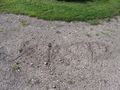
Field was a field of long grass, with an open gate. They don't come a lot easier than that. I arrived around 18:00. Took some pictures. Wrote XKCD in the gravel of the driveway opposite to the open gate to the hashpoint. And took a longer way home.
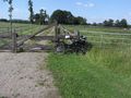
The bike.
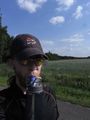
The man, sucking.
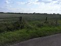
The open gate.
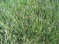
The to-be-trampled-grass.
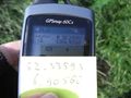
Coordinates reached.

Happy hasher.
View to the bike from the hashpoint.
View from the road to the hashpoint.
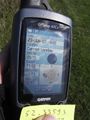
Time&date.
Tag.
Tag left, bike right.
Tag in the front, hashpoint in the back.


