Difference between revisions of "2009-07-14 49 -122"
From Geohashing
imported>Rhonda (→Plans: trail note) |
imported>Rhonda |
||
| Line 1: | Line 1: | ||
| − | |||
| − | |||
| − | |||
| − | |||
{{meetup graticule | {{meetup graticule | ||
| lat=49 | | lat=49 | ||
| Line 9: | Line 5: | ||
}} | }} | ||
| − | |||
| − | |||
== Location == | == Location == | ||
In the Siskin Lake/Robin Lake area, east of Buntzen Lake on top of a mountain. There are established hiking trails there. See hiking trails map in photos section. | In the Siskin Lake/Robin Lake area, east of Buntzen Lake on top of a mountain. There are established hiking trails there. See hiking trails map in photos section. | ||
| Line 28: | Line 22: | ||
== Expedition == | == Expedition == | ||
| + | Park gates closed at 9PM and we didn't want to have the car locked in the park overnight. We reached our designated turnaround time before we reached the hashpoint. | ||
| + | |||
| + | Full report tomorrow. | ||
| Line 39: | Line 36: | ||
</gallery> | </gallery> | ||
| − | |||
| − | |||
| − | |||
| − | |||
| − | |||
[[Category:Expeditions]] | [[Category:Expeditions]] | ||
[[Category:Expeditions with photos]] | [[Category:Expeditions with photos]] | ||
| − | |||
| − | |||
| − | |||
| − | |||
| − | |||
| − | |||
| − | |||
| − | |||
| − | |||
[[Category:Coordinates not reached]] | [[Category:Coordinates not reached]] | ||
| − | + | [[Category:Not reached - Time constraints]] | |
| − | |||
| − | [[Category:Not reached - | ||
| − | |||
| − | |||
| − | |||
Revision as of 05:12, 15 July 2009
| Tue 14 Jul 2009 in 49,-122: 49.3504257, -122.8322685 geohashing.info google osm bing/os kml crox |
Location
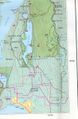
In the Siskin Lake/Robin Lake area, east of Buntzen Lake on top of a mountain. There are established hiking trails there. See hiking trails map in photos section.
Participants
Plans
Meet after work (leaving as early as possible) and drive to Buntzen Lake picnic area. Hike ~4km on a trail (note: switchbacks - may be longer, will be steep), find hash point, hike down.
Sunset is at 9:13PM. We're bringing headlamps and jackets (and emergency gear) in case we're returning in the dark. Weather forecast calls for clearing skies through the day.
- Robyn will transit to North Shore (meet where? chez toi, Rhonda?) What time is "after work"?
- leaving North Vancouver at 1500, picking Xore up at 1530.
Expedition
Park gates closed at 9PM and we didn't want to have the car locked in the park overnight. We reached our designated turnaround time before we reached the hashpoint.
Full report tomorrow.
Tracklog
Photos
map
