Difference between revisions of "2009-07-14 57 16"
From Geohashing
imported>Jonatan (→Expedition) |
imported>Jonatan (→Photos) |
||
| Line 24: | Line 24: | ||
== Photos == | == Photos == | ||
<gallery perrow="3"> | <gallery perrow="3"> | ||
| − | Image:2009-07-14-57-16- | + | Image:2009-07-14-57-16-2.jpg | Jonatan and Gabriel |
| − | + | Image:2009-07-14-57-16-3.jpg | View from Källahamn | |
| + | Image:2009-07-14-57-16-4.jpg | Jonatan | ||
</gallery> | </gallery> | ||
Revision as of 09:22, 16 July 2009

| Tue 14 Jul 2009 in 57,16: 57.1064036, 16.9918096 geohashing.info google osm bing/os kml crox |
Participants
Expedition
As we are currently staying at my (Jonatans) parents summer residence, we took our chance to meet a new graticule today. Due to some issues with one of my legs (because of a too long biking trip, a few days ago...) we simply had to be lazy and go by car to the hash point. Well, we had a nice (and fairly easy) morning trip to a breathtakingly beautiful hash point - perhaps both the easiest and most beautiful one I (still Jonatan) have done this far. The hash point were situated by the sea close to a small fishing dock on the northern part and eastern side on Öland, the Island we're staying at the moment.
Track-log
Achievements
Jonatan, Gabriel earned the Land geohash achievement
|
Photos

Jonatan and Gabriel

View from Källahamn
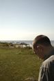
Jonatan


