Difference between revisions of "2009-07-14 57 16"
From Geohashing
imported>Jonatan m (→Achievements) |
imported>FippeBot m (Location) |
||
| (One intermediate revision by one other user not shown) | |||
| Line 20: | Line 20: | ||
== Achievements == | == Achievements == | ||
| − | + | {{land geohash | latitude = 57 | longitude = 16 | date = 2009-07-14 | name = [[User:Jonatan|Jonatan]], [[User:Gabriel|Gabriel]]}} | |
== Photos == | == Photos == | ||
| Line 32: | Line 32: | ||
[[Category:Coordinates reached]] | [[Category:Coordinates reached]] | ||
[[Category:Expeditions with photos]] | [[Category:Expeditions with photos]] | ||
| + | {{location|SE|H}} | ||
Latest revision as of 04:31, 8 August 2019

| Tue 14 Jul 2009 in 57,16: 57.1064036, 16.9918096 geohashing.info google osm bing/os kml crox |
Participants
Expedition
As we are currently staying at my (Jonatans) parents summer residence, we took our chance to meet a new graticule today. Due to some issues with one of my legs (because of a too long biking trip, a few days ago...) we simply had to be lazy and go by car to the hash point. Well, we had a nice (and fairly easy) morning trip to a breathtakingly beautiful hash point - perhaps both the easiest and most beautiful one I (still Jonatan) have done this far. The hash point were situated by the sea close to a small fishing dock on the northern part and eastern side on Öland, the Island we're staying at the moment.
Track-log
Achievements
Jonatan, Gabriel earned the Land geohash achievement
|
Photos
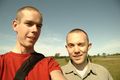
Jonatan and Gabriel
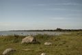
View from Källahamn
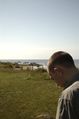
Jonatan


