Difference between revisions of "2009-07-20 60 25"
imported>Small oaks |
imported>Small oaks |
||
| Line 35: | Line 35: | ||
Image:2009-07-20-60-25 7.jpg|Top of the hill | Image:2009-07-20-60-25 7.jpg|Top of the hill | ||
</gallery> | </gallery> | ||
| + | {{Walk geohash | ||
| + | | latitude = 60 | ||
| + | | longitude = 25 | ||
| + | | date = 2009-07-20 | ||
| + | | name = [[User:Small oaks|Small oaks]] | ||
| + | | distance = 3km | ||
| + | }} | ||
[[Category:Expeditions]] | [[Category:Expeditions]] | ||
[[Category:Expeditions with photos]] | [[Category:Expeditions with photos]] | ||
Revision as of 21:59, 20 July 2009
| Mon 20 Jul 2009 in Vantaa: 60.3827741, 25.6606590 geohashing.info google osm bing/os kml crox |
About
These coordinates were located in the Vantaa, Finland graticule on 2009-07-20, in Porvoo city inside the slalom hill of Kokoniemi..
60°22.966', 25°39.639'
Our second tried geohashing location expedition was successful.
People
People who reached these coordinates:
10pm CET -3 hours
Small oaks mr.
Expedition and Photos
It was 9 pm already when I noticed that there was Geohashing location just 1.5 km from our home. Location was quite familiar since I have been almost at the coordinates a few times while geocaching.
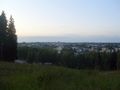
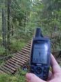
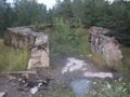
I walked all the way and it was quite easy as there were walking routes almost all the way. Exept the final 100 meters.. Then I crossed one of the slalom slopes in a small forest. There a small suprise and geohashing coordinates waited. Wooden bridge and wooden paths that I did't knew nothing about. After I reached coordinates I climbed on top of the hill to see the view to city. Also I made a detour to the artillery base that can be found just 60 meters from the geohashing location. Nice evening walks and happy to make it.
50 meters to go
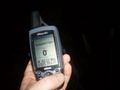
zero point..
near by bridge
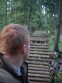
Mr was here
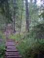
Wooden trail..bridge.
60 m away
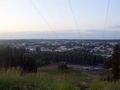
Top of the hill


Small oaks earned the Walk geohash Achievement
|