Difference between revisions of "2009-07-21 42 -72"
imported>Sara m (expand that subst:Expedition!) |
imported>Sara (Expedition to Granby, CT) |
||
| Line 1: | Line 1: | ||
| − | |||
<!-- If you did not specify these parameters in the template, please substitute appropriate things for IMAGE, LAT, LON, and DATE (YYYY-MM-DD format) --> | <!-- If you did not specify these parameters in the template, please substitute appropriate things for IMAGE, LAT, LON, and DATE (YYYY-MM-DD format) --> | ||
<!-- | <!-- | ||
| Line 14: | Line 13: | ||
== Location == | == Location == | ||
| + | In a patch of woods in Granby, Connecticut, behind some houses. | ||
== Participants == | == Participants == | ||
| + | [[User:Sara|Sara]] | ||
| + | |||
| + | == Expedition == | ||
| + | |||
| + | It was pouring rain and I really was supposed to leave for the office, but I couldn't resist a hashpoint in the Connecticut part of the graticule, where I had never done a hash. I carefully packed a dry pair of pants, socks, and shoes, and then left the house without the spare shoes. | ||
| − | + | On the way there, I drove right past [[2009-06-14_42_-72|the site of my first geohash]], stopping neither for coffee nor for prayer. | |
| + | Google satellite view showed some cleared areas in the woods near the hashpoint, and I had thought maybe that was a farm, but sadly it turned out to be the site of a future subdivision. There was no place to park safely near the cleared areas, so I drove to the other side of the hashpoint, parked, and walked into the woods. | ||
| − | + | The GPS worked as well as could be expected in the woods in the rain, but walking around in circles was kind of pleasant, because it was very pretty and the walking wasn't hard. | |
| + | The really interesting thing in those woods was the old stone walls. I'm going to look into whether those stone walls might have been defining the area of an orchard, a vegetable plot, a foundation or something else, but it's interesting that now the area is all filled in fairly tall trees (aside from where the trees have been cut down to build houses), but at one point all the the area inside the stone walls must have been cleared (by hand). | ||
| − | + | The GPS eventually said it was about 8 feet from the hashpoint, and it said its margin of error was something like 22 feet, so I stopped, considered the point reached, and tried to take pictures. It was so wet and buggy that I forgot to mark the location. The pictures are lousy - does anyone have any tips about taking a good picture of the GPS readout in the rain with the flash bouncing off the screen? | |
| + | Getting back to the car was easier than finding the hashpoint. On the way back to the highway, I saw that just like [[2009-07-15_42_-72|the last place I went geohashing]], North Granby, CT has a cute little library and post office across the street from each other. I went on to the office and wore wet shoes all day. | ||
== Photos == | == Photos == | ||
<gallery perrow="3"> | <gallery perrow="3"> | ||
| − | Image:2009- | + | Image:2009-07-21_42_-72_stonewall.JPG | It was pouring, and this picture doesn't show how pretty the forest was. |
| − | Image:2009- | + | Image:2009-07-21_42_-72_blurry_gps.JPG | Although this is illegible, I offer it as proof of location because you may be able to see that it shows a distance less than 10 feet to go, and GPS accuracy was about 22 feet. |
| + | Image:2009-07-21_42_-72_grin.jpg | The required grin picture | ||
| + | Image:2009-07-21_42_-72_library.JPG | I stopped briefly at this cute library on the way back. | ||
| + | Image:2009-07-21_42_-72_po.JPG | This cute post office is across the street from the cute library. This time I didn't send anyone a hashcard. | ||
</gallery> | </gallery> | ||
<!-- Potential categories. Please include all the ones appropriate to your expedition --> | <!-- Potential categories. Please include all the ones appropriate to your expedition --> | ||
| − | |||
| − | |||
| − | |||
| − | |||
| − | |||
| − | |||
| − | |||
[[Category:Expeditions]] | [[Category:Expeditions]] | ||
[[Category:Expeditions with photos]] | [[Category:Expeditions with photos]] | ||
| − | |||
| − | |||
| − | |||
| − | |||
| − | |||
[[Category:Coordinates reached]] | [[Category:Coordinates reached]] | ||
| − | |||
| − | |||
| − | |||
| − | |||
| − | |||
| − | |||
| − | |||
| − | |||
| − | |||
| − | |||
Revision as of 12:49, 22 July 2009
| Tue 21 Jul 2009 in 42,-72: 42.0188884, -72.8363438 geohashing.info google osm bing/os kml crox |
Location
In a patch of woods in Granby, Connecticut, behind some houses.
Participants
Expedition
It was pouring rain and I really was supposed to leave for the office, but I couldn't resist a hashpoint in the Connecticut part of the graticule, where I had never done a hash. I carefully packed a dry pair of pants, socks, and shoes, and then left the house without the spare shoes.
On the way there, I drove right past the site of my first geohash, stopping neither for coffee nor for prayer.
Google satellite view showed some cleared areas in the woods near the hashpoint, and I had thought maybe that was a farm, but sadly it turned out to be the site of a future subdivision. There was no place to park safely near the cleared areas, so I drove to the other side of the hashpoint, parked, and walked into the woods.
The GPS worked as well as could be expected in the woods in the rain, but walking around in circles was kind of pleasant, because it was very pretty and the walking wasn't hard.
The really interesting thing in those woods was the old stone walls. I'm going to look into whether those stone walls might have been defining the area of an orchard, a vegetable plot, a foundation or something else, but it's interesting that now the area is all filled in fairly tall trees (aside from where the trees have been cut down to build houses), but at one point all the the area inside the stone walls must have been cleared (by hand).
The GPS eventually said it was about 8 feet from the hashpoint, and it said its margin of error was something like 22 feet, so I stopped, considered the point reached, and tried to take pictures. It was so wet and buggy that I forgot to mark the location. The pictures are lousy - does anyone have any tips about taking a good picture of the GPS readout in the rain with the flash bouncing off the screen?
Getting back to the car was easier than finding the hashpoint. On the way back to the highway, I saw that just like the last place I went geohashing, North Granby, CT has a cute little library and post office across the street from each other. I went on to the office and wore wet shoes all day.
Photos
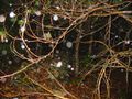
It was pouring, and this picture doesn't show how pretty the forest was.
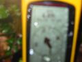
Although this is illegible, I offer it as proof of location because you may be able to see that it shows a distance less than 10 feet to go, and GPS accuracy was about 22 feet.

The required grin picture
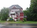
I stopped briefly at this cute library on the way back.
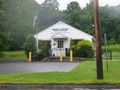
This cute post office is across the street from the cute library. This time I didn't send anyone a hashcard.


