Difference between revisions of "2009-07-23 37 -121"
From Geohashing
imported>Elness |
imported>FippeBot m (Location) |
||
| (2 intermediate revisions by 2 users not shown) | |||
| Line 16: | Line 16: | ||
<gallery widths="150px" heights="100px" perrow="3"> | <gallery widths="150px" heights="100px" perrow="3"> | ||
| − | Image: | + | Image:2009-07-23_37_-121_elness1.jpg|[[User:elness|elness]] at the hashpoint in the almond orchard. |
Image:Geohash2.jpg|GPS near the hashpoint in the almond orchard. Needed to move a bit to find adequate sunlight for the photo. | Image:Geohash2.jpg|GPS near the hashpoint in the almond orchard. Needed to move a bit to find adequate sunlight for the photo. | ||
</gallery> | </gallery> | ||
== Achievements == | == Achievements == | ||
| − | {{land geohash | latitude = 37 | longitude = -121 | date = 2009-07- | + | {{land geohash | latitude = 37 | longitude = -121 | date = 2009-07-23 | name = [[User:elness|elness]] }} |
[[Category:Expeditions]] | [[Category:Expeditions]] | ||
<!--[[Category:Expeditions with photos]] commented out pending photos--> | <!--[[Category:Expeditions with photos]] commented out pending photos--> | ||
[[Category:Coordinates reached]] | [[Category:Coordinates reached]] | ||
| + | {{location|US|CA|ST}} | ||
Latest revision as of 02:35, 6 August 2019
| Thu 23 Jul 2009 in 37,-121: 37.6954191, -121.0956819 geohashing.info google osm bing/os kml crox |
Contents
Location
Just inside an orchard on Toomes Road near Bacon Road, southwest of Salida.
People
The Tale
This one was reasonably close to my route home from work. I parked nearby on the side of the road just after 4 PM and found the hash coordinates to be just inside an almond orchard.
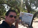
elness at the hashpoint in the almond orchard.
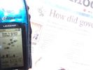
GPS near the hashpoint in the almond orchard. Needed to move a bit to find adequate sunlight for the photo.


Achievements
elness earned the Land geohash achievement
|