Difference between revisions of "2009-07-30 50 11"
(2002) |
imported>Ekorren (Undo revision 207881 by 122.255.81.101 (Talk)) |
||
| Line 1: | Line 1: | ||
| − | + | {{meetup graticule | |
| + | | map=<map lat="50" lon="11" date="2009-07-30" /> | ||
| + | | lat=50 | ||
| + | | lon=11 | ||
| + | | date=2009-07-30 | ||
| + | }} | ||
| + | |||
| + | This hashpoint was way too far south for [[User:Reinhard|Reinhard]] to just cycle there and back in the evening from Jena, but Reinhard liked the location near the Frankenwald-Hochstraße ("Franken forest high street" - a scenic street along the mountain ridge of the Frankenwald) and wanted to get to know that area a little better and naturally had to GPS track a lot of new roads for the [http://www.rennrad-tourenplaner.de/Tourenplaner/Tourenplaner quaeldich.de bike trip planner]. So, Reinhard went most of the way by car and parked in Bad Lobenstein, from where he started his very hilly bike trip. Landscape was beautiful and the roads were always going up and down (more than Reinhard thought, when he planned the tour at home). When he saw the castle "Burg Lauenstein", he even had to take this climb, though it wasn't part of his plan. After arriving at the Frankenwald-Hochstraße, it wasn't far to the point, where he had to leave it and continue on the forest path for about 300 m. There he got off his bike, took a photo of the bright moon, the dark forest (it was getting dark now) and the lonely geohasher and walked the last 50 m through smaller plants into the wood. Coordinates reached! | ||
| + | |||
| + | It was getting colder then and Reinhard was getting hungrier, because he had nothing else to eat than a small cereal bar, but there were only 35 km and probably several ascents left. When there were only 15 km to go and Reinhard came through Lehesten for the second time, he wanted to use the shortest way, which meant ignoring the road works that forced him to use the sidewalk. That turned out not to be the best idea, because Reinhard wasn't concentrated enough to see the thick blue cable on the ground and had no chance to cross it without getting thrown off the bike. For the third time within one week he fell on his left knee. Luckily, nothing serious happened, so that Reinhard could continue his trip to Bad Lobenstein, where he got after 83 km and 1760 m total ascent. He then continued his journey by car to Leipzig, where he arrived at Manu sometime after midnight. | ||
| + | |||
| + | <gallery caption="Photo Gallery" widths="200px" heights="200px" perrow="4"> | ||
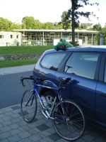
| + | Image:20090730-50N11E 1.jpg|Kriko and Dracho wished good luck to me, but prefered to stay in the car. | ||
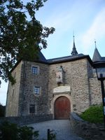
| + | Image:20090730-50N11E 2.jpg|Visiting Burg Lauenstein. | ||
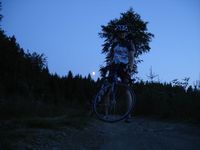
| + | Image:20090730-50N11E 3.jpg|On the forest path close to the hashpoint with the Frankenwald-Hochstraße (not visible) in the back. | ||
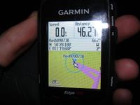
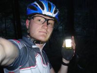
| + | Image:20090730-50N11E 4.jpg|Coordinates reached. | ||
| + | Image:20090730-50N11E 5.jpg|That's how the Frankenwald looks in the evening. | ||
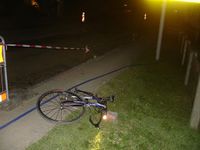
| + | Image:20090730-50N11E 6.jpg|Damn blue cable for the road works made me falling. I must have had a guardian angel, that I didn't hit the brick. Bike still exactly at the place where I dramatically got off it. | ||
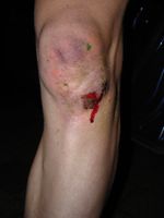
| + | Image:20090730-50N11E 7.jpg|One wound for playing squash, one for dumb cycling and the shiny red one for geohashing at night ... | ||
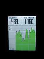
| + | Image:20090730-50N11E 8.jpg|That looks like the perfect rollercoaster track. | ||
| + | </gallery> | ||
| + | |||
| + | |||
| + | [[Category:Expeditions]] | ||
| + | [[Category:Expeditions with photos]] | ||
| + | [[Category:Coordinates reached]] | ||
Revision as of 23:52, 14 February 2010
| Thu 30 Jul 2009 in 50,11: 50.4696622, 11.3280326 geohashing.info google osm bing/os kml crox |
This hashpoint was way too far south for Reinhard to just cycle there and back in the evening from Jena, but Reinhard liked the location near the Frankenwald-Hochstraße ("Franken forest high street" - a scenic street along the mountain ridge of the Frankenwald) and wanted to get to know that area a little better and naturally had to GPS track a lot of new roads for the quaeldich.de bike trip planner. So, Reinhard went most of the way by car and parked in Bad Lobenstein, from where he started his very hilly bike trip. Landscape was beautiful and the roads were always going up and down (more than Reinhard thought, when he planned the tour at home). When he saw the castle "Burg Lauenstein", he even had to take this climb, though it wasn't part of his plan. After arriving at the Frankenwald-Hochstraße, it wasn't far to the point, where he had to leave it and continue on the forest path for about 300 m. There he got off his bike, took a photo of the bright moon, the dark forest (it was getting dark now) and the lonely geohasher and walked the last 50 m through smaller plants into the wood. Coordinates reached!
It was getting colder then and Reinhard was getting hungrier, because he had nothing else to eat than a small cereal bar, but there were only 35 km and probably several ascents left. When there were only 15 km to go and Reinhard came through Lehesten for the second time, he wanted to use the shortest way, which meant ignoring the road works that forced him to use the sidewalk. That turned out not to be the best idea, because Reinhard wasn't concentrated enough to see the thick blue cable on the ground and had no chance to cross it without getting thrown off the bike. For the third time within one week he fell on his left knee. Luckily, nothing serious happened, so that Reinhard could continue his trip to Bad Lobenstein, where he got after 83 km and 1760 m total ascent. He then continued his journey by car to Leipzig, where he arrived at Manu sometime after midnight.
- Photo Gallery
