Difference between revisions of "2009-08-02 47 -122"
imported>Thomcat (New page: {{meetup graticule | lat=47 | lon=-122 | date=2009-08-02 }} __NOTOC__ == Location == == Participants == *Thomcat will be there midday. == Plans == == Expedition == ...) |
imported>FippeBot m (Location) |
||
| (2 intermediate revisions by one other user not shown) | |||
| Line 7: | Line 7: | ||
__NOTOC__ | __NOTOC__ | ||
== Location == | == Location == | ||
| − | + | In greenspace behind some houses in rural area. | |
== Participants == | == Participants == | ||
| − | *[[User:Thomcat|Thomcat]] | + | *[[User:Thomcat|Thomcat]] |
| − | |||
| − | |||
| − | |||
== Expedition == | == Expedition == | ||
| + | Drove across the state to come home and stopped here. Where in the greenspace? Good question. I found a trail leading back into the area, but the geohash point was off trail of course. Judging by the satellite map, it wasn't far behind these fences, but I could not for the life of me get a good reading on the GPS. | ||
| + | I measured several points (photos below) and wandered all over the area. The GPS signal was low to none under the tree cover, and at one point showed me coordinates in the back yard of a nearby house. I took several measurements and tried to connect the dots, but that didn't show me crossing the hashpoint. See the discussion for a multi-coord page I found and my explored coordinates list. | ||
| − | + | My conclusion is that the GPS wasn't showing me anything, but I could see that I was behind the appropriate house and in the right general area. Also, I found a cool ribbon tied on a tree. For this geohash, I claim success and a multihash, the second five graticules west of the first. | |
| − | |||
== Photos == | == Photos == | ||
| − | + | <gallery perrow="5"> | |
| − | <gallery perrow=" | + | Image:2009-08-02_47_-122_Lilo.jpg | Parked by the trail entrance |
| − | Image:2009- | + | Image:2009-08-02_47_-122_Neighborhood.jpg | The neighborhood |
| − | Image:2009- | + | Image:2009-08-02_47_-122_Trailhead.jpg |
| + | Image:2009-08-02_47_-122_Trail.jpg | Not much trail after this | ||
| + | Image:2009-08-02_47_-122_Bearing.jpg | It's behind that second house | ||
| + | Image:2009-08-02_47_-122_GroundCover.jpg | Varied ground cover | ||
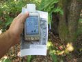
| + | Image:2009-08-02_47_-122_OnePoint.jpg | Hard to get measurements | ||
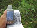
| + | Image:2009-08-02_47_-122_ASign.jpg | Could this be a sign? | ||
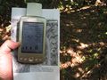
| + | Image:2009-08-02_47_-122_NoSign.jpg | GPS coords are not good | ||
| + | Image:2009-08-02_47_-122_Trees.jpg | ||
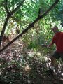
| + | Image:2009-08-02_47_-122_Curious.jpg | Could this be a good spot? | ||
| + | Image:2009-08-02_47_-122_OrHere.jpg | Or here? | ||
| + | Image:2009-08-02_47_-122_AnotherBearing.jpg | Yet another | ||
</gallery> | </gallery> | ||
| − | |||
| − | |||
| − | |||
| − | |||
| − | |||
| − | |||
[[Category:Expeditions]] | [[Category:Expeditions]] | ||
[[Category:Expeditions with photos]] | [[Category:Expeditions with photos]] | ||
| − | + | ||
| − | |||
| − | |||
| − | |||
| − | |||
[[Category:Coordinates reached]] | [[Category:Coordinates reached]] | ||
| − | + | {{location|US|WA|KN}} | |
| − | |||
| − | |||
| − | |||
| − | |||
| − | |||
| − | |||
| − | |||
| − | |||
| − | |||
Latest revision as of 04:57, 8 August 2019
| Sun 2 Aug 2009 in 47,-122: 47.5333294, -122.1774206 geohashing.info google osm bing/os kml crox |
Location
In greenspace behind some houses in rural area.
Participants
Expedition
Drove across the state to come home and stopped here. Where in the greenspace? Good question. I found a trail leading back into the area, but the geohash point was off trail of course. Judging by the satellite map, it wasn't far behind these fences, but I could not for the life of me get a good reading on the GPS.
I measured several points (photos below) and wandered all over the area. The GPS signal was low to none under the tree cover, and at one point showed me coordinates in the back yard of a nearby house. I took several measurements and tried to connect the dots, but that didn't show me crossing the hashpoint. See the discussion for a multi-coord page I found and my explored coordinates list.
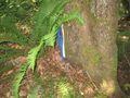
My conclusion is that the GPS wasn't showing me anything, but I could see that I was behind the appropriate house and in the right general area. Also, I found a cool ribbon tied on a tree. For this geohash, I claim success and a multihash, the second five graticules west of the first.
Photos
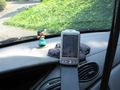
Parked by the trail entrance
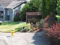
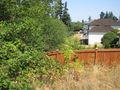
The neighborhood
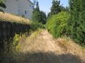
Not much trail after this
It's behind that second house
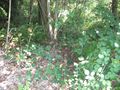
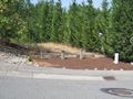
Varied ground cover
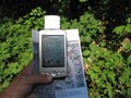
Hard to get measurements
Could this be a sign?
GPS coords are not good

Could this be a good spot?
Or here?
Yet another


