Difference between revisions of "2009-08-02 47 -117"
imported>Thomcat (New page: {{meetup graticule | lat=47 | lon=-117 | date=2009-08-02 }} __NOTOC__ == Location == == Participants == *Thomcat plans to start his westward trip here. == Plans == ...) |
imported>FippeBot m (Location) |
||
| (3 intermediate revisions by one other user not shown) | |||
| Line 7: | Line 7: | ||
__NOTOC__ | __NOTOC__ | ||
== Location == | == Location == | ||
| − | + | Behind an unfinished house near Mica/Freeman/Valleyford. | |
== Participants == | == Participants == | ||
*[[User:Thomcat|Thomcat]] plans to start his westward trip here. | *[[User:Thomcat|Thomcat]] plans to start his westward trip here. | ||
| − | == | + | == Expedition == |
| − | + | Early morning, time for a geohash! I drove out from the place I was staying to Mica, just south of the Spokane Valley where I grew up. The house in question was fairly easy to find, it was unknown just how far the geohash was away from that point though. | |
| − | + | This house has been under construction for a while, apparently, so I hopped up and hiked through the meadows. | |
| + | Quite a pretty view from the hash point itself. Me, I would build a house right up here, not down there. Build a garage down by the road, sure, but save the living room view for beauty! | ||
| − | + | Hash successful, I started my journey back to Seattle, where I would attempt another geohash. | |
| + | (Editor's note - according to [http://zillow.com/homedetails/16717-E-Washington-Rd-Valleyford-WA-99036/84143687_zpid/ Zillow], this property sold about four months later for $175,000) | ||
== Photos == | == Photos == | ||
| − | |||
<gallery perrow="3"> | <gallery perrow="3"> | ||
| − | Image:2009- | + | Image:2009-08-02_47_-117_Lilo.jpg | Parked |
| − | Image:2009- | + | Image:2009-08-02_47_-117_House1.jpg | The house |
| + | Image:2009-08-02_47_-117_House2.jpg | Was up | ||
| + | Image:2009-08-02_47_-117_House3.jpg | a Hill | ||
| + | Image:2009-08-02_47_-117_TheSpot.jpg | Here's the spot! | ||
| + | Image:2009-08-02_47_-117_Grin.jpg | ||
| + | Image:2009-08-02_47_-117_View.jpg | I would definitely | ||
| + | Image:2009-08-02_47_-117_View2.jpg | build up here! | ||
</gallery> | </gallery> | ||
| − | |||
| − | |||
| − | |||
| − | |||
| − | |||
| − | |||
[[Category:Expeditions]] | [[Category:Expeditions]] | ||
[[Category:Expeditions with photos]] | [[Category:Expeditions with photos]] | ||
| − | |||
| − | |||
| − | |||
| − | |||
| − | |||
[[Category:Coordinates reached]] | [[Category:Coordinates reached]] | ||
| − | + | {{location|US|WA|SP}} | |
| − | |||
| − | |||
| − | |||
| − | |||
| − | |||
| − | |||
| − | |||
| − | |||
| − | |||
Latest revision as of 04:57, 8 August 2019
| Sun 2 Aug 2009 in 47,-117: 47.5333294, -117.1774206 geohashing.info google osm bing/os kml crox |
Location
Behind an unfinished house near Mica/Freeman/Valleyford.
Participants
- Thomcat plans to start his westward trip here.
Expedition
Early morning, time for a geohash! I drove out from the place I was staying to Mica, just south of the Spokane Valley where I grew up. The house in question was fairly easy to find, it was unknown just how far the geohash was away from that point though.
This house has been under construction for a while, apparently, so I hopped up and hiked through the meadows.
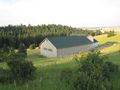
Quite a pretty view from the hash point itself. Me, I would build a house right up here, not down there. Build a garage down by the road, sure, but save the living room view for beauty!
Hash successful, I started my journey back to Seattle, where I would attempt another geohash.
(Editor's note - according to Zillow, this property sold about four months later for $175,000)
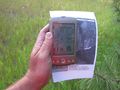
Photos
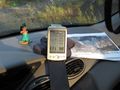
Parked
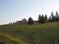
The house
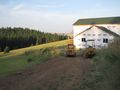
Was up
a Hill
Here's the spot!

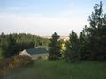
I would definitely
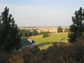
build up here!


