Difference between revisions of "2009-08-04 51 8"
imported>El muerte verde (New page: {{meetup graticule | lat=51 | lon=8 | date=2009-08-04 }} __NOTOC__ == Location == A field just outside of Ehringhausen. == Participants == * El muerte verde ...) |
imported>FippeBot m (Location) |
||
| (4 intermediate revisions by 3 users not shown) | |||
| Line 15: | Line 15: | ||
== Expedition == | == Expedition == | ||
| − | + | Since I have been lurking this has been the first geohash close enough and on a day i actually had time. It was somewhere I have never been before so I took my dad's GPS, uploaded the rout from google maps and tried my luck. | |
| + | I decided to take a bit of a longer way home for the Tron achievement. The area of the hash point was encircled by a fence and my GPS said it was only 4 more meters anyway, so I decided it was good enough. I made the photos but before i could include the goofy smile photo the battery died (better always check the battery before leaving from now on). | ||
| + | The way home was way more exhausting and took longer than I thought, and a lot of the way was through cities and on a motorway. But I got home save and was happy with reaching my 1st hash. | ||
== Tracklog == | == Tracklog == | ||
| Line 36: | Line 38: | ||
== Achievements == | == Achievements == | ||
| − | {{land geohash | latitude = 51 | longitude = 8 | date = | + | {{land geohash | latitude = 51 | longitude = 8 | date = 2009-08-04 | name = El muerte verde }} |
| − | {{Bicycle geohash | latitude = 51 | longitude = 8 | date = | + | {{Bicycle geohash | latitude = 51 | longitude = 8 | date = 2009-08-04 | name = El muerte verde | distance = 26.3 km | image = 2009-08-04 51 8 3.jpg }} |
| − | {{Tron | latitude = 51 | longitude = 8 | date = | + | {{Tron | latitude = 51 | longitude = 8 | date = 2009-08-04 | name = El muerte verde | tracklog = http://maps.google.com/maps?f=d&source=s_d&saddr=ziethenweg+1+paderborn&daddr=N51%C2%B039'18.18%22,+E8%C2%B026'44.25%22+to:Heidfeldweg+to:Unknown+road+to:51.645494,8.444431+to:Im+Quinhagen+to:Im+Quinhagen+to:Marienloher+Str.+to:Wiesenpfad+to:Schatenweg+to:ziethenweg+30+paderborn&geocode=%3BFYoxFAMdud6AAA%3BFestFAMdw8SAAA%3BFS8YFAMduLqAAA%3B%3BFYFkFQMdxfqEAA%3BFaGIFQMd4faEAA%3BFV6FFQMduxGFAA%3BFU6WFQMdOkWFAA%3BFYKmFQMdSj-FAA%3B&hl=en&mra=dpe&mrcr=1&mrsp=4&sz=16&via=2,3,4,5,6,7,8,9&dirflg=w&sll=51.647637,8.446791&sspn=0.010265,0.019205&ie=UTF8&ll=51.751902,8.73971&spn=0.040967,0.076818&t=h&z=14 | possessive = his }} |
| − | {{Picnic | latitude = 51 | longitude = 8 | date = | + | {{Picnic | latitude = 51 | longitude = 8 | date = 2009-08-04 | name = El muerte verde | image = 2009-08-04 51 8 3.jpg | food = apples }} |
| Line 47: | Line 49: | ||
[[Category:Expeditions with photos]] | [[Category:Expeditions with photos]] | ||
[[Category:Coordinates reached]] | [[Category:Coordinates reached]] | ||
| + | {{location|DE|NW|SO}} | ||
Latest revision as of 05:00, 8 August 2019
| Tue 4 Aug 2009 in 51,8: 51.6550512, 8.4456251 geohashing.info google osm bing/os kml crox |
Location
A field just outside of Ehringhausen.
Participants
Expedition
Since I have been lurking this has been the first geohash close enough and on a day i actually had time. It was somewhere I have never been before so I took my dad's GPS, uploaded the rout from google maps and tried my luck. I decided to take a bit of a longer way home for the Tron achievement. The area of the hash point was encircled by a fence and my GPS said it was only 4 more meters anyway, so I decided it was good enough. I made the photos but before i could include the goofy smile photo the battery died (better always check the battery before leaving from now on). The way home was way more exhausting and took longer than I thought, and a lot of the way was through cities and on a motorway. But I got home save and was happy with reaching my 1st hash.
Tracklog
I had to recreate the tracklog in http://maps.google.com for the lack of knowledge about the GPS prevented me from logging the ride. The distance overall distance was actually a bit more because I had to cycle around a construction side in Schloß Neuhaus on ways I couldn't mark in maps.google.com thus resulting in 60 km of total way cycled. [1]
Photos
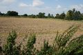
The field with the hashpoint
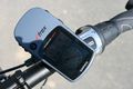
Just 4 meters? That's good enough!
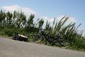
My bike and picnic. Sadly the battery died on me after this photo. *facepalm*


Achievements
El muerte verde earned the Land geohash achievement
|
El muerte verde earned the Bicycle geohash achievement
|
El muerte verde earned the Tron achievement
|
El muerte verde earned the Picnic achievement
|