Difference between revisions of "2009-05-22 41 -84"
imported>Excellentdude m (Fixed Template) |
imported>Excellentdude (Working my way through the list. Here's a success!) |
||
| Line 8: | Line 8: | ||
== About == | == About == | ||
| + | The day's geohash coordinates fell in a farm of some sort (please don't tell my farming family that I didn't know what kind it was). | ||
| + | == Expedition == | ||
| + | [[User:excellentdude|excellentdude]]: The day had arrived where I would be leaving [[Lansing, Michigan|mid-Michigan]] for the summer and returning to [[Kirksville, Missouri]], for my annual summer job. There would be a few stops (and a few geohashes) along the way, though, of course. So, before I left, I looked to see where the day's geohash coordinates fell along my potential paths to Missouri. Quite luckily for me, one set of coordinates fell less than 5 miles off one major highway I normally use. Also, these particular coordinates happened to be in Michigan in a graticule that only has about a quarter of its area in Michigan. So visiting these coordinates would help with some of my regional geohashing goals as well! | ||
| + | |||
| + | With the car loaded up for the summer, I set off down I-69. About an hour later, I took an exit off the highway and quickly found myself in the general area of the coordinates. I pulled into the driveway of the nearest house to find a man mowing the yard with a riding lawn mower and a woman doing touch up work with a push mower. The woman was just finishing as I pulled up and got out of my car. I explained what I wanted to do and asked if the geohash was on their land. She said it was, and that the two have a son who is a geocacher. She saw no problem with what I wanted to do, but since her husband was finishing and pulling up right about that time, she thought I should ask him first. Not only was he OK with it, but he said it was OK if I wanted to drive my car most of the way back to the hash. While tempting, my car isn't the greatest off-road car, and if the grass was wet at all I'd be stuck no matter how flat the ground was. So I passed on that, but thanked them both and proceeded to the hash. | ||
| − | + | A grassy pathway led me most of the way to the hash. The field I needed to enter was fenced, but after a bit of walking, there was an opening in the fence. After surveying the situation for a bit, I decided that I could enter the field at that point and walk to the hash without damaging the densely packed crops, thus saving myself of the trouble of getting over a fence without damaging crops later. I soon found two rows of crops with a wider than normal separation between them. I walked south along that space until I got to the proper latitude. I then carefully made my way east to the correct longitude for the day's hash. Success! I took the normal pictures and headed back out the way I came. When I arrived back at the house, the friendly woman and I had a pleasant conversation for about ten minutes. After that time, I decided I needed to hit the highway again, but because she was interested I gave her the address of the wiki before I left. All in all, between the weather, the people, and the location, this was a very pleasant geohash. | |
| − | |||
== Achievements == | == Achievements == | ||
| Line 20: | Line 24: | ||
| name = excellentdude | | name = excellentdude | ||
}}{{Ambassador geohash | }}{{Ambassador geohash | ||
| + | | latitude = 41 | ||
| + | | longitude = -84 | ||
| + | | date = 2009-05-22 | ||
| + | | name = excellentdude | ||
| + | }}{{Virgin graticule | ||
| latitude = 41 | | latitude = 41 | ||
| longitude = -84 | | longitude = -84 | ||
| Line 27: | Line 36: | ||
== Photos == | == Photos == | ||
| − | <gallery perrow=" | + | <gallery perrow="3"> |
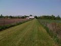
| + | Image:2009-05-22 41 -84 Path Between Fields.jpg|Getting to this hash was pretty easy | ||
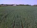
| + | Image:2009-05-22 41 -84 Fortunate Path.jpg|Surprisingly still easy once in the field | ||
| + | Image:2009-05-22 41 -84 Hash.jpg|The hash itself | ||
| + | Image:2009-05-22 41 -84 Goofy Grin.jpg|Obligatory goofy grin | ||
| + | Image:2009-05-22 41 -84 GPS.PNG|Proof! | ||
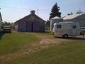
| + | Image:2009-05-22 41 -84 Barn From Hash.jpg|The barn in front of the house and road I came from | ||
| + | Image:2009-05-22 41 -84 Heading Out.jpg|Heading back to the house | ||
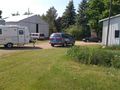
| + | Image:2009-05-22 41 -84 Lawn Alpha.jpg|The back of the yard | ||
| + | Image:2009-05-22 41 -84 Lawn Beta.jpg|More toward the house | ||
</gallery> | </gallery> | ||
Revision as of 23:12, 18 August 2009
| Fri 22 May 2009 in Defiance: 41.7912766, -84.9191959 geohashing.info google osm bing/os kml crox |
Contents
About
The day's geohash coordinates fell in a farm of some sort (please don't tell my farming family that I didn't know what kind it was).
Expedition
excellentdude: The day had arrived where I would be leaving mid-Michigan for the summer and returning to Kirksville, Missouri, for my annual summer job. There would be a few stops (and a few geohashes) along the way, though, of course. So, before I left, I looked to see where the day's geohash coordinates fell along my potential paths to Missouri. Quite luckily for me, one set of coordinates fell less than 5 miles off one major highway I normally use. Also, these particular coordinates happened to be in Michigan in a graticule that only has about a quarter of its area in Michigan. So visiting these coordinates would help with some of my regional geohashing goals as well!
With the car loaded up for the summer, I set off down I-69. About an hour later, I took an exit off the highway and quickly found myself in the general area of the coordinates. I pulled into the driveway of the nearest house to find a man mowing the yard with a riding lawn mower and a woman doing touch up work with a push mower. The woman was just finishing as I pulled up and got out of my car. I explained what I wanted to do and asked if the geohash was on their land. She said it was, and that the two have a son who is a geocacher. She saw no problem with what I wanted to do, but since her husband was finishing and pulling up right about that time, she thought I should ask him first. Not only was he OK with it, but he said it was OK if I wanted to drive my car most of the way back to the hash. While tempting, my car isn't the greatest off-road car, and if the grass was wet at all I'd be stuck no matter how flat the ground was. So I passed on that, but thanked them both and proceeded to the hash.
A grassy pathway led me most of the way to the hash. The field I needed to enter was fenced, but after a bit of walking, there was an opening in the fence. After surveying the situation for a bit, I decided that I could enter the field at that point and walk to the hash without damaging the densely packed crops, thus saving myself of the trouble of getting over a fence without damaging crops later. I soon found two rows of crops with a wider than normal separation between them. I walked south along that space until I got to the proper latitude. I then carefully made my way east to the correct longitude for the day's hash. Success! I took the normal pictures and headed back out the way I came. When I arrived back at the house, the friendly woman and I had a pleasant conversation for about ten minutes. After that time, I decided I needed to hit the highway again, but because she was interested I gave her the address of the wiki before I left. All in all, between the weather, the people, and the location, this was a very pleasant geohash.
Achievements
excellentdude earned the Land geohash achievement
|
excellentdude earned the Ambassador achievement
|
Photos
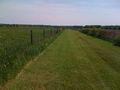
Getting to this hash was pretty easy
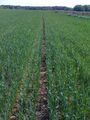
Surprisingly still easy once in the field
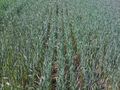
The hash itself

Obligatory goofy grin
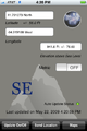
Proof!
The barn in front of the house and road I came from
Heading back to the house
The back of the yard
More toward the house


